We are pleased to announce that TAP Mapper 2018.4 is now available. This new release includes:
- Composite Talkback Studies
- Offline Shapefile Basemaps
- Layer Info Mode
composite talkback studies
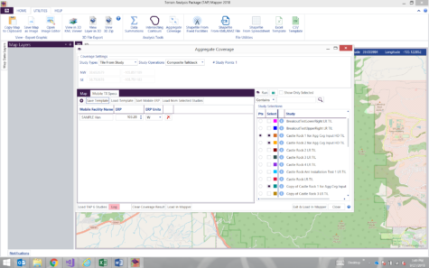
In TAP vernacular, Talkback is the performance of mobile facilities / handhelds being able to communicate back to fixed facility base stations. Standard coverage studies are Talkout and the reverse study is Talkback. For TAP users with Aggregate Coverage module availability, TAP Mapper will perform a composite talkback study to show the expected talkback performance of multiple types of mobile radios communicating to multiple fixed base stations. Select the studies of interest and then use the Load from Selected Studies button to populate the Mobile TX Specs list with mobile ERP values from the selected studies. Use the ‘+’ button to manually add to the list. Click the Run button to calculate a Composite Talkback result for each defined mobile facility. Mobile Facility Names must be unique. The Composite Talkback result shapefile will show where each mobile will have Talkback coverage and to which fixed facility.
offline shapefile basemaps
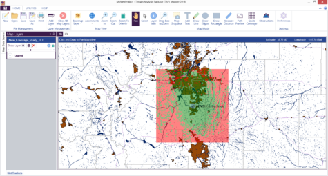
TAP Mapper provides many options for internet-connected users to work with basemaps from OpenStreetmaps, Bing, Mapquest, and USGS. Roads, hillshading, and satellite imagery provide attractive and informative base layers for showing RF coverage maps and these are the recommended basemap layers when an internet connection is available. If Mapper is operating on a computer without an internet connection then it can make use of locally-hosted shapefiles containing administrative boundaries, roads, water, and more to create an attractive presentation without an internet connection. Contact sales@softwright.com for more information on obtaining shapefiles and configuring offline basemaps for your geographical areas of interest.
layer info mode
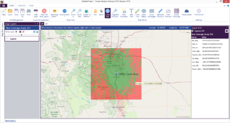
The new Layer Info mode is a quick and easy way to view the data embedded in a shapefile layer at a glance. Simply click Layer Info on the main ribbon bar then use the mouse tip icon to enable mouse tips for your layers of interest. As the mouse is moved over a selected layer with mouse tips enabled, all of the embedded data for the uppermost layer at that mouse location is shown in the right-hand side panel. In the example below, a coverage layer is loaded and all of the saved study information at the mouse location is displayed in the side panel. Left-click the map to “capture” the mouse location and freeze that data in the side panel. Deselect the capture check-box to re-enable live updating of the layer info panel.
For more information on licensing and using the latest TAP 7 or TAP Mapper software, please contact sales@softwright.com.