We are pleased to announce today that we have posted Terrain Analysis Package (TAP™) Mapper 2018.3, which includes an all-new Adjacent Channel Interference (ACI) analysis module, new U.S. Boundary data layers, and a new Help Menu with Quick Start Guide.
Adjacent Channel interference module
The ACI module computes the interfering effects between stations. Given user-configurable specifications for a receiver, including the received power of the desired signal and the frequency offset of the undesired signals, the resulting receiver rejection specifications are used to determine which locations will have service and which locations will not due to interfering signals.
TAP™ Mapper 2018.3 features a new Adjacent Channel Interference (ACI) Module. The ACI Module, although licensed separately, is integrated in the Aggregate Coverage utility as an additional aggregation operation. Component coverage studies of interest may be loaded individually as Mapper layers for use in Aggregate Coverage or, alternatively, all TAP™ studies may be imported with a single button click.
Click on the Aggregate Coverage button in the Utility tab of the main menu and then choose Adjacent Channel Interference from the Study Operation list. The Rx Rejection Specs dialog shown below will appear.
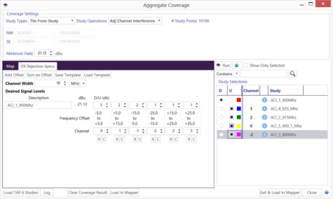
Use the Rx Rejection Specs dialog to set the channel width and enter receiver rejection specifications for the receiver of interest. The Study Selections grid will automatically calculate and show the Channels associated with each component study based on the width and Tx frequency for each study. The Rx Rejection Specs may be Saved as a template for future reuse. Select the ‘D’esired and ‘U’ndesired (interfering) studies from the Study Selection grid and then click Run. An example ACI output is shown below.
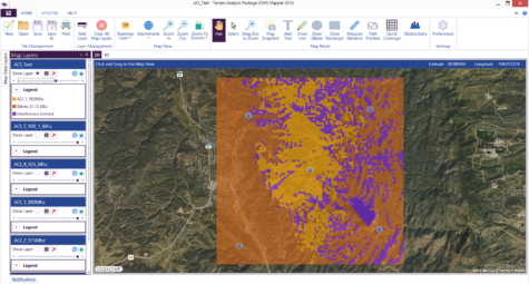
The output result above shows (1) coverage from the selected ‘D’ facility, (2) where the coverage is interference limited, and (3) where the signal strength is below the required threshold.
For more information on the new ACI module or how to update a Mapper subscription or TAP™ maintenance plan, please call (800) 728-4033 x1 or email sales@softwright.com.
U.S. Boundary data layers
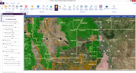
Mapper 2018.3 includes a set of U.S. boundary data layers that are especially useful when using satellite imagery basemaps. As shown below, these boundary layers include State, County (or equivalent), National Forest, BLM, National Park, Military Installations, and other administrative boundaries of interest. Simply hover over the Map Data Layers button to select and set the opacity for the desired boundary layers.