- Floating License
- Map data layers
- Global elevation
- NLCD & MODIS land cover
- Map Snapshot
And, for Mapper 2017 users with either a current TAP maintenance subscription or a Mapper 2017 subscription, we now offer worldwide Path Preview as described below.
For more information on subscribing to TAP™ Mapper, please contact sales@softwright.com.
Mapper Path Preview
The Path Preview feature uses elevation data accessed via the internet to provide a quick path preview between two points. The path preview may optionally include land cover information and building data along the path as well. Note that an internet connection is required in order to use path preview. In demo mode, path preview is only available within Colorado, USA. In fully licensed mode, the path preview is available worldwide.
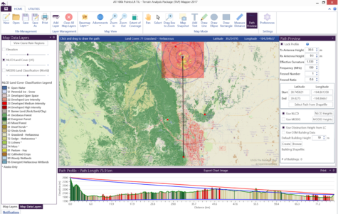
The figure above shows a path preview on the lower panel below the main map view. The path preview endpoints may be manually entered on the right side panel, selected by clicking and dragging a line on the map, or selected from any point type shapefile loaded in the map.
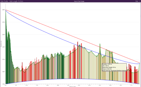
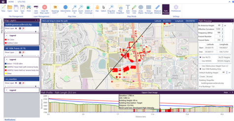
Obstructions along the path may be added either based on the land cover category or based on building data from Open Street Maps. In the above graphic, obstructions above the terrain are added based on NLCD land cover category. In the graphic below, buildings have been automatically imported along the path and the building heights are added to the path preview where the path crosses the imported building footprints.
Complete, detailed instructions for how to set up and run Path Previews and add Data Layers are included in the new release of TAP™ Mapper 2017. Watch our video: What’s New in TAP™ Mapper 2017.