We are pleased to announce today that we have released Terrain Analysis Package (TAP™) Mapper 2017.2, which includes Longley-Rice Propagation for RF Path and Quick Coverage Calculations as well as a built-in 3D viewer with 3D buildings. As previously announced, Mapper is available to users of our full TAP™ RF design software and it is now also available as a standalone software subscription.
Longley-RIce Propagation and Quick Coverage Calculations
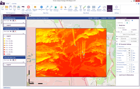
With the inclusion of Longley-Rice, our most versatile and popular RF propagation model, the previously released Path Preview now includes received field strength prediction at the receiver. In addition, we have added a Quick Coverage feature that provides a simple way to set up and run an area coverage study that will predict RF signal strength over an area. As shown below, the coverage prediction can include 3D buildings. Note that an internet connection is required in order to use Path Preview and Quick Coverage. In demo mode, these features are only available within Colorado, USA. In fully licensed mode, these features are available worldwide.
built-in 3d viewer
TAP™ Mapper still provides kml export capability for viewing coverage maps in third-party 3D mapping software, such as Google Earth. However, it now also features a built-in 3D viewer. Simply click on the 3D tab and the current map view will be shown in 3D.
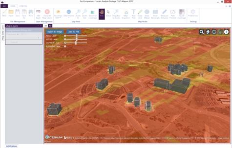
If Mapper is currently in Path Preview mode then the 3D path preview is shown. Otherwise, the current 2D map view is shown as a 3D overlay. Add land cover (NLCD or MODIS) using the check boxes and use the buttons to export the 3D image for use in a document or report or to load a 3D file. For instructions on how to control the 3D view, click on the ‘?’ button in the upper right.
For more information or to purchase your Mapper license, please contact call 800-728-4033 ext 1 or email at sales@softwright.com.