We are pleased to announce today that we have released Terrain Analysis Package (TAP™) Mapper 2017.3, which includes Obstruction Editor with 3D Open Street Map (OSM) buildings plus manual obstructions as well as new KML/KMZ to shapefile conversion. As previously announced, Mapper is available to users of our full TAP™ RF design software and it is now also available as a standalone software subscription.
obstruction editor
One of the most common questions that we receive is how to import and use clutter and obstructions in TAP™
propagation studies. Many studies are made more accurate by the inclusion of 3D buildings. A widespread global database of 3D buildings is available from Open Street Maps (OSM). However, it does not include every building or other structure (water tower, wind turbine, etc.) that may impact RF propagation.
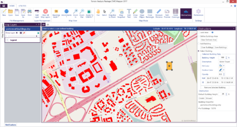
With the release of TAP™ Mapper 2017, users can now import OSM buildings for an area of interest. And, as shown below, use the Obstruction mode to manually enter location and height information for known obstructions not available from OSM. These OSM and manual obstructions may then be saved together in a single obstructions shapefile for use in TAP™ Mapper Path Preview or Quick Coverage. The associated dbf file may also be used as a TAP™ 6 surface feature file in path and coverage studies.
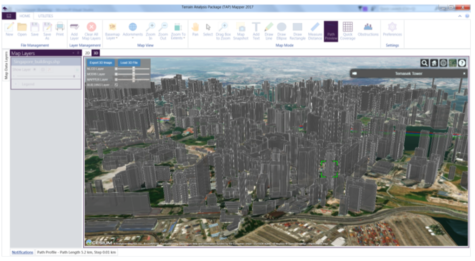
Switch over to the built-in 3D view and check the box to show the buildings layer and see the buildings in 3D as shown below.
Then use the Obstructions in Path Preview or, as shown below, in Quick Coverage, and see the RF shadowing due to buildings and other obstructions.
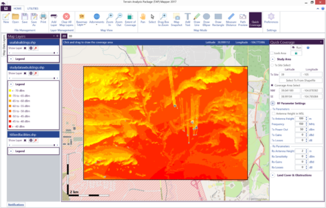
The figure above shows Quick Coverage result where the transmitter is located south of the coverage area and the buildings (shown in gray) result in shadowing of the RF signal. The Quick Coverage right hand side panel is used to quickly and easily define the coverage area, set RF parameters, and include land cover or building obstructions as desired.
kml and kmz file to shapefile conversion
Increasingly, RF site, facility, and boundary information is contained and shared in the popular KML and KMZ file formats. TAP™ 6, TAP™ Mapper and many other applications operate data contained in Esri shapefiles. Now in addition to exporting to KML/KMZ, TAP™ Mapper also provides the ability to import many KML and KMZ files and convert them to shapefiles (shp). Once the files have been converted to shp and added as map layers, points, lines, and polygons may be styled and used for analysis just like any other shapefile.