SoftWright’s Terrain Analysis Package (TAP™) provides well-known, industry accepted RF propagation models, such as Longley-Rice, Bullington, Okumura, Hata-Davidson, and others. These models have been widely used for many years and demonstrated to be accurate based on measured field strength data. However, these models calculate RF propagation losses over terrain and the accuracy does depend on the quality of the topographical and land use data included in the study. SoftWright is pleased to announce that we now have 1 arcsecond (~30 m) resolution topo data for most of the world. This will replace the 3 arcsecond resolution data that we have been offering outside of North America. For a limited time, we are offering this higher-resolution data at the same price as our older data. Now may be a great time to use end-of-year funds to upgrade topographical data sets.
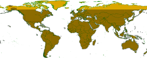
TAP™ is used on all 7 continents (yes, even Antarctica!) and in over 70 countries around the world. Outside of North America, SoftWright has been offering 3 arcsecond resolution elevation data, which is approximately 90 meters in data step size. Site elevation values are calculated based on interpolating between points on a grid having step size of 90 meters.
For the new data set, the measurements are at 1 arcsecond or approximately 30 meter grid step size. This is nine times greater point density in the topo elevation grid. Whether working in path studies or area coverage studies in steep to undulating terrain, this higher resolution data set will improve the accuracy of your study results. And, as aforementioned, we have not increased the prices for this new and improved data! The world map below shows where SoftWright now has availability of 1 arcsecond or better topo data.
We also have new sources of worldwide high-resolution clutter and land use data. These data sets are custom packages put together to meet specific customer requirements. For more information, please or contact sales@softwright.com.