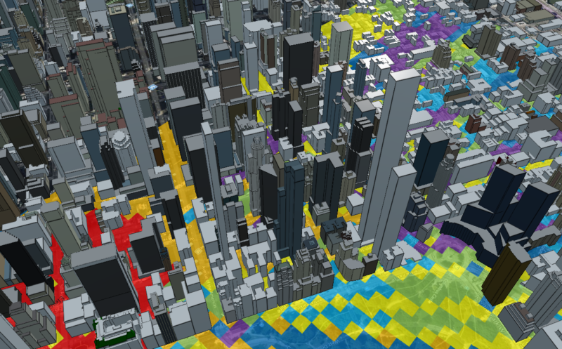
We are pleased to announce that we have released Terrain Analysis Package (TAP™) 7.6.4 with several exciting new features headlined by the integration of OpenStreetMap (OSM) buildings directly within TAP™ Path, Coverage, AutoPath, and AutoCoverage Studies. With this latest software release, TAP™ provides the user with the option to import 3D buildings along a path or over a coverage area. This feature does require internet access to contact online servers that host OpenStreetMap building data. Other new features in TAP™ 7.6.4 include:
- MBTiles: A new option for basemaps without internet access using raster images saved in a local MBTiles file. MBTiles files may be downloaded from several online sources or created using GIS tools, including the free QGIS (www.qgis.org) software. Basemaps, including satellite imagery, may be stored in MBTiles for offline use in the field or whenever internet access is not available.
- Mapper 3D Viewer: The 3D view built into TAP™ Mapper has been upgraded to a new 3D viewing technology. The viewer includes the OpenStreetMap buildings layer and a variety of basemap options. Create and export 3D visualizations directly from within TAP™ Mapper, or load path KML files generated in TAP™.
Click here to see a tutorial video of How to Use OSM Buildings and MBTiles in TAP™.
In the latest in a series of new features to make TAP™ RF analysis even more detailed, users can now import OpenStreetMap 3D building data directly into TAP™ Path, AutoPath, Coverage, and AutoCoverage studies. OpenStreetMap building data access requires internet access and make take several minutes or more to download depending on the size of the area and the number of buildings contained therein. The quality of 3D building data available within OpenStreetMaps varies greatly depending on the municipality; however, high-quality data will continue to become available at more and more locations around the globe. Many urban areas already have high-quality 3D building data available from OpenStreetMaps.
It is straightforward to import OpenStreetMap building data into any supported TAP™ study type. Simply go to the Surface Features tab in the study settings area. From the Clutter Type dropdown list, select Surface Features. If the Path or Coverage Area is defined then select Download Buildings and the download will begin for an area along a path or for the complete defined coverage area as shown below.
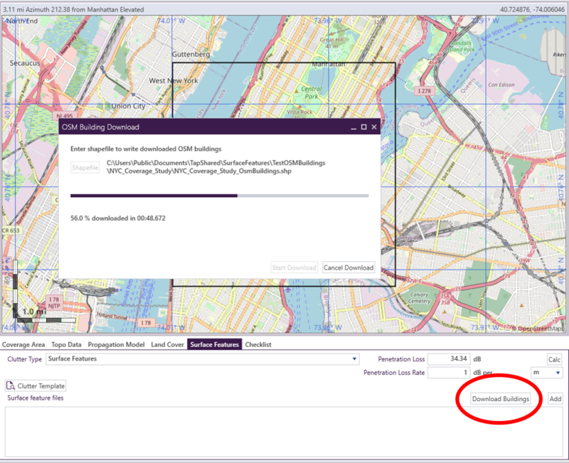
When the download is complete, a shapefile containing the building data is created and displayed on the map view. The building data will then be used in the coverage study based on the penetration and loss rate value settings as in prior TAP™ versions.
The new integrated OpenStreetMap download feature and the MBTiles for offline basemap features are available to users with maintenance expiration dates on or after September 1, 2022. Contact us at sales@softwright.com to update maintenance or get more information on TAP 7.6.4.