TAP™ Mapper is an RF analysis and visualization software tool available as a standalone subscription product as well as for use alongside the full TAP™ RF engineering software. TAP™ Mapper is a Windows desktop application that accesses global terrain and land cover data via the internet in order to facilitate RF engineering tasks. It provides ultra fast loading, rendering, and styling of shapefiles.
TAP™ Mapper is available to our full TAP RF Engineering customers and also as a standalone subscription product:
- 30 Day Subscription: US $199.00
- Annual Subscription: US $1,999.00
Please feel free to try out the demo version, and contact sales@softwright.com to subscribe to TAP™ Mapper and receive your instant activation license key.
TAP™ Mapper features
- Web Basemap Layers – For customers using TAP™ Mapper from an internet-connected computer, web basemaps including Open Street Maps, Bing Maps, and MapQuest, plus basemap layers from the USGS National Map are available.
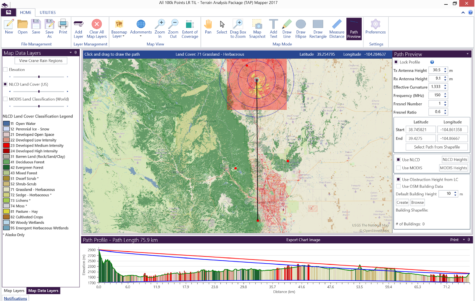
- Built-in 3D View – View path profiles, coverage maps, and buildings in built-in 3D viewer just by clicking on the 3D tab.
- OSM Buildings – Acquire and display 3D buildings from Open Street Maps (OSM) and use the OSM buildings as obstructions in RF propagation calculations. Define regions of interest and acquire buildings from the millions of buildings in the worldwide OSM database.
- File Conversion – Convert kml and kmz files to Esri shapefile (shp) and vice-versa as well as create shapefiles from data contained in spreadsheet formats .csv and .xlsx by selecting latitude and longitude data columns.
- Longley-Rice RF Propagation – Predict received field strength for RF paths and area coverage studies quickly and easily. Optionally include land cover clutter data and 3D buildings.
- Map Data Layers – Global map overlay of elevation data, NLCD Land Cover data (U.S. Only), and MODIS Land Cover data.
- Global RF Path Preview – The software provides global terrain, land use, and 3D building data that enable worldwide RF path analysis.
- Quick Coverage Study – Run RF area coverage studies to predict field strength over an area using Longley-Rice (aka Irregular Terrain Model – ITM) propagation calculations, worldwide terrain and land cover data, and OSM buildings.
- Additional 3D Export Options – TAP™ maps may now be exported as KML files with georeferenced images or as standalone KML or KMZ files with embedded shape information for improved 3D viewing at all zoom levels.
- Improved Map Annotations – Map annotations, such as Transmit Facility Markers and Range Circles, as well as text and drawing elements, may now be added to the map using a modern interface for styling and customization.
- Enhanced Presentation of Results – Each map layer now includes an Analysis Report that numerically and graphically summarizes the data in the layer and produces a report that may be edited, saved, and printed as required.
- Aggregate Coverage Module – Combine coverage results from individual sites into a composite, multi-site coverage map using Best Server and Simulcast Delay Spread parameters.
- Adjacent Channel Interference Tool – The ACI tool computes the interfering effects between stations. Given user-configurable specifications for a receiver, including the received power of the desired signal and the frequency offset of the undesired signals, the resulting receiver rejection specifications are used to determine which locations will have service and which locations will not due to interfering signals.