We are pleased to announce that we have released Terrain Analysis Package (TAP™) 7.6.9 with several new features recently requested by customers. If you have ideas for features that you would like to see in a future TAP™ release, let us know at support@softwright.com. Highlights of TAP™ 7.6.9 include:
- New LTE Calculations in the Aggregate Coverage Module: Many customers use our popular Aggregate Coverage Module to analyze multi-site coverage networks, including Best Server and Simulcast systems. TAP™ 7.6.9 allows users to do additional calculations specifically to support multi-site LTE system design and analysis.
- Simultaneous Land Cover and Building/Obstruction Losses: TAP™ supports several methods to account for losses due to what is on top of the terrain. These methods can be based on Land Cover categories or discrete surface features/obstructions, such as 3D building data. Historically, users had to either select Land Cover or discrete surface features to use in a study. With the release of TAP™ 7.6.9, users can now use both Land Cover data and surface features in the same study. When using this new option, for any points that do not fall within a discrete surface feature, Land Cover is used to determine the feature height.
LTE CALCULATIONS IN AGGREGATE COVERAGE
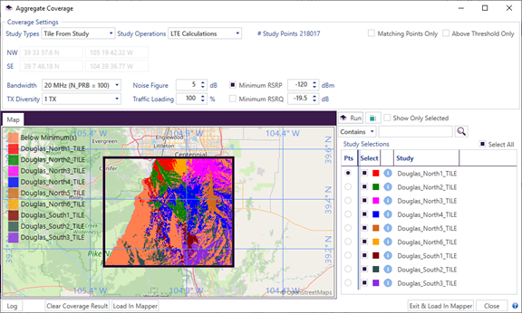
Users with maintenance expiration dates later than December 1, 2023, will have access to the new Aggregate Coverage calculations. The LTE Calculations aggregation operation calculates the Reference Signal Received Power (RSRP, in dBm) and Reference Signal Received Quality (RSRQ, in dB) from the TalkOut received power of multiple sites. The LTE Calculations operation has six parameters: (1) Bandwidth, which sets the number of physical resource blocks (N_PRB); (2) TX Diversity, set to one or two transmitters active; (3) Noise Figure, in dB; (4) Traffic Loading, from 0%, with reference signals only, to fully loaded at 100%; (5) Minimum RSRP, in dBm; and (6) Minimum RSRQ, in dB. There are checkboxes for the Minimum RSRP and Minimum RSRQ that allow the user to select whether they are used as thresholds. For study points that fall below the selected minimum(s), they are assigned in the COVSOURCE field as “Below Minimum(s).” After running the aggregate study and loading the result into Mapper, the RSRP_dBm and RSRQ_dB output fields can be selected under the Value Range Style tab in the study’s layer settings, Style tab. The LTE Calculations setup window and example results output are shown below.