We are pleased to announce today that we have released Terrain Analysis Package (TAP™) 7.6.3 with an all-new way to include clutter losses based on land cover category in RF path and coverage analyses. Until now, TAP™ users with licensed Land Cover Module could include losses based on the land cover category at the receiver location. With this latest software release, TAP™ provides the user with the option to effectively raise the terrain based on land cover categories in order to more accurately predict signal blockage due to buildings, trees, and other vegetation. Click here to see a tutorial video of how to include Land Cover Clutter in Propagation Studies.
Land Cover data, also known as Land Use data, categorizes locations according to what is on top of the terrain. The USGS NLCD land cover data categories include Forest Deciduous, Forest Evergreen, Developed Low Intensity, Developed High Intensity, and many more categories. TAP™ includes a Land Cover Loss Database that correlates the land classification with a loss value as a function of frequency. When TAP™ is used for an area coverage study or single-point field calculation, the local environment of the mobile/receiver location can be determined from the Land Use data, and a user-specified loss value can be applied. This approach is particularly useful for statistical analysis of large area coverage, where detailed surface feature data is not available; this is a common type of analysis for public safety LMR.
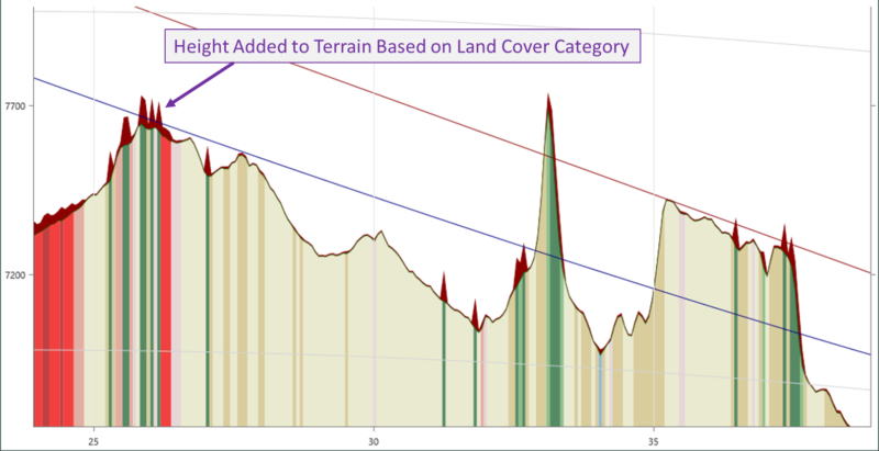
With this latest release, TAP™ users with licensed Land Cover Module and maintenance date of April 1, 2022 or later, have the option to also specify a height associated with each land cover category based on knowledge of the local environment. For example, Forest Deciduous height of 15 meters, Forest Evergreen 25 meters, etc. TAP™ will raise the terrain accordingly in propagation calculations for Path, Coverage, AutoPath, and AutoCoverage studies. This functionality is shown graphically below with Land Cover Clutter selected as the Surface Feature type and the dark red showing the height added to the bare ground terrain.
SoftWright has the NLCD 2019 Land Cover dataset available for the U.S. and MODIS Land Cover dataset available outside of the U.S. The popular Land Cover module now lets users apply land cover clutter losses based on the land cover category at the receiver location, raise terrain heights based on land cover categories along the path, or include both types of clutter losses when appropriate.