Land Use Data and Path Loss
Q: If my path profile using Land Use data shows trees along the path why is a loss value not included in the field strength calculation?
Q: Can I use both Land Use files and Surface Feature files when computing field strength on a path profile or area coverage study, or should I only select one or the other?
A: It is important to understand that Land Use data losses are applied for the Land Use classification at the receiver location.
Note that all values in this example are for demonstration purposes only. You should determine appropriate settings for your application.
This discussion assumes that there is a Land Use Loss Template entry for the frequency you are using. If no loss entry is included for your frequency in the template you have selected, no loss value is computed.
If you do have a valid Land Use Loss Template selected, and it includes a range for your operating frequency, the loss value will be computed based on the Land Use classification at the receiver location.
This is different from the way losses are computed based on TAP Surface Feature files. In general (as explained below),
· Surface Feature files are used to account for obstacles along the path from the transmitter to the receiver location.
o Surface Feature files are created by you for areas of interest and obstacles of concern.
o Surface Feature files contain height information for buildings, trees, etc.
o Surface Feature files do not include any category information. All obstacles in the Surface Feature files increase the elevation along the path wherever the path intersects the obstacle. Everything is treated as a solid obstruction.
· Land Use files are used to account for the losses due to the immediate environment around the receiver location.
o Land Use files are generated from USGS databases. They can be created or edited using TAP utilities.
o Land Use data files include the type of area such as Urban, Residential, Commercial, Rangeland, etc.
o Land Use data files do not include any height information. Forest or Residential areas are assigned loss values without regard to the height or density of the trees or houses.
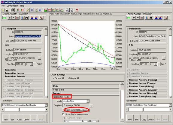
For example, consider the demo profile shown:
The “Calc Field at RX Location” button in the Propagation Model section can be used to compute the field strength using the selected propagation model:
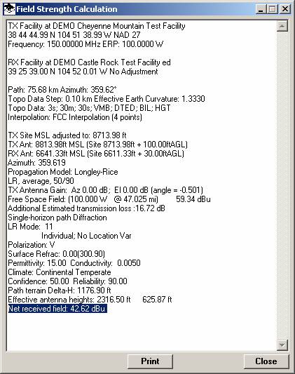
The computed field strength is displayed:
Land Use and/or Surface Features can be included in the calculation as described below.
Land use files consist of data arranged in a rectangular grid, with each grid location assigned a Land Use classification, such as “Rangeland,” “Commercial,” “Residential,” etc. When Land Use data is included in field strength calculations, the classification at the receiver location is used to assign a loss value.
The loss values are in the Land Use Template files, which can be created or edited in TAP. The template contains the applicable frequency ranges for the Land Use classifications of interest. For example, a lower frequency VHF signal would have better reception in an industrialized area than a UHF signal, all other factors being equal.
Therefore, the sample “TIA TR8 (Revised)” Land Use Loss Template provided with TAP contains different loss values at different frequencies for the “Urban or Built-up Land: Industrial” classification: 4dB of additional loss for a 50MHz system and 20dB for an 800MHz system. This represents the degradation of the different signals when the receiver is in an industrial environment. In contrast, for a receiver location in “Rangeland” would add 10dB of loss for the 800MHz system and only 1dB for the VHF system.
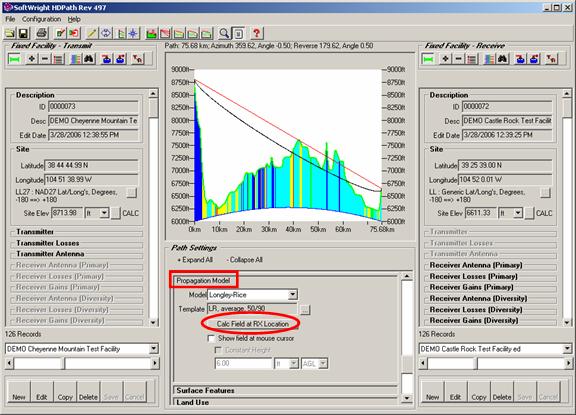
None of these values are affected by Land Use information along the path. For example, consider the demo profile shown with the “Include Land Use Data” box checked in the Land Use section of the form.
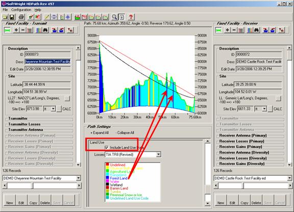
There are areas of “Forest Land” along the path.
The “Calc Field at RX Location” button in the Propagation Model section can be used to compute the field strength using the selected propagation model:
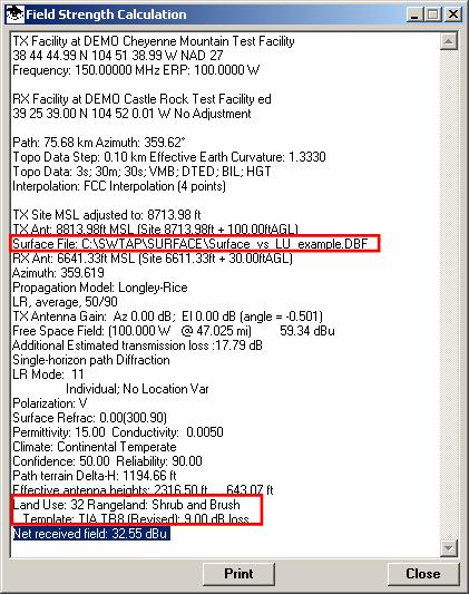
The computed field value includes the adjustment for the Land Use classification (Rangeland) at the receiver location:
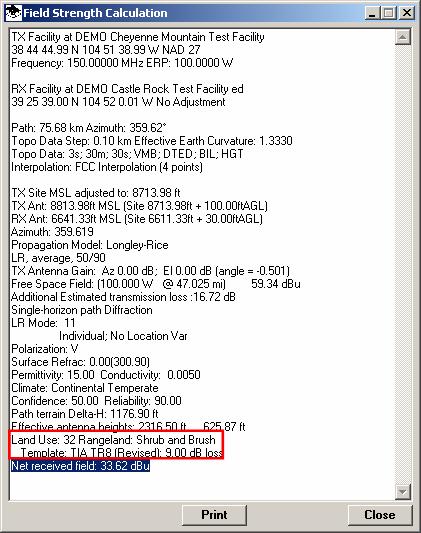
The computed received field strength at the location has been adjusted for the effect of the immediate environment of the receiver. The Land Use information of the forested land along the path is not a part of the calculation using the Land Use data.
To include the effect of obstacles (such as vegetation or man-made clutter) you can add Surface Feature information.
For example, based on the indication of forested land from the Land Use files, you could add Surface Feature objects on the demo path to represent 100-foot trees in those areas:
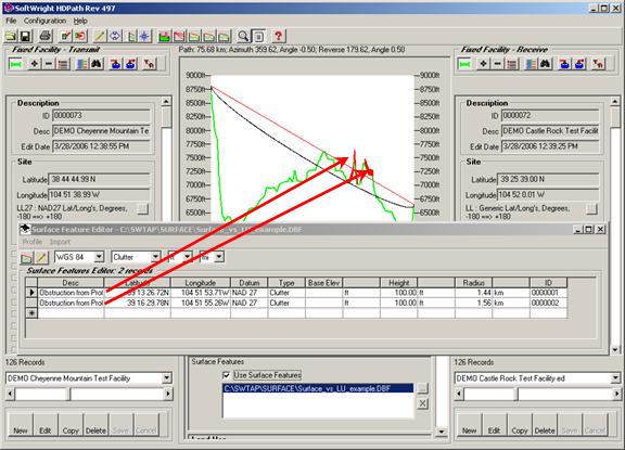
The Land Use data can often provide general guidelines for adding Surface Feature information in an area.
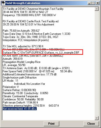
Now, the “Calc Field at RX Location shows a lower computed field strength because of the additional obstacles along the path:
Both effects can be included as well:
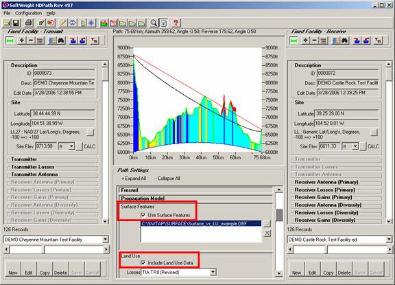
Now the computed field shows the effects of both the Surface Feature obstructions along the path and the Land Use classification at the receiver location:
Using both Surface Features and Land Use data will enable you to include both effects, should you feel this is appropriate. For example, if you are computing field strength in a developed area (with different residential and commercial sections) while parts of the paths between the transmitter site and the target areas is heavily forested, both effects can be considered simultaneously.
However, as another example, if the area coverage calculation is primarily over forested land, including both effects may overcompensate for the effects of the vegetation. The field strength values will be reduced because of the Surface Feature obstructions along the path, and by the “Forest Area” Land Use classification at receiver locations in the forested area itself.
In mixed areas you might choose to create one or more new Land Use Loss Templates that include only losses for Urban classifications and remove the loss values for Forest areas. This would enable TAP to use the Land Use effects in populated areas.
On the other hand, using the Land Use data alone in areas where you have not created Surface Feature files for a forest can give a field strength value that includes some consideration for the vegetation. As always, employing your good engineering judgment is essential in using the design tools effectively. Understanding the different ways Land Use and Surface Feature files are implemented in TAP will help you make these engineering judgments in a way which is most appropriate to your particular application.
|
|
Copyright 2007 by SoftWright LLC