Longley-Rice Variability Effects
Q: How do the Longley-Rice Variability values affect the field strength predictions?
A: The variability factors in the Longley-Rice model adjust the computed field strength values based on the length of the path, antenna heights, terrain roughness, and other factors.
The Longley-Rice model is discussed in detail in Notes on Longley-Rice Propagation. In addition, the general effects of variability are discussed in Longley-Rice Variability Values.
It is important to consider the effects of different variability settings in the Longley-Rice calculations. For example, you can use different settings to determine the “best case” and “worst case” coverage areas for your installation.
The following sample paths illustrate the kind of differences in predicted field strength values for 50%, 90%, and 99.9% variabilities for time and situation variability settings. (Most TAP Longley-Rice calculations use the Variability Mode setting of “11” which ignores location variability.)
These sample paths are intended as illustrations only. You can use the TAP Single Point Field function and make similar changes in the variability values to see the effect on paths that are typical in your installation.
Sample Path 1
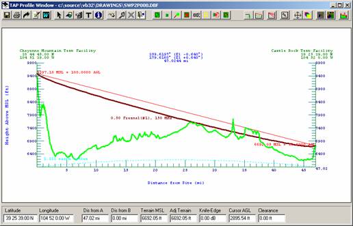
Cheyenne Mtn to Castle Rock
Cheyenne Mountain Test Facility: 38 44 45.00 N 104 51 39.00 W
Frequency: 150.00000 MHz ERP: 100.0000 W
Castle Rock Test Facility: 39 25 39.00 N 104 52 0.00 W
Path: 47.0244 mi; Azimuth 359.6197
Step: 0.1000 mi; Effective Earth Curvature: 1.333
Topo Data:
Interpolation: FCC Interpolation (4 points)
TX Site MSL adjusted to: 9397.18 ft
TX Ant: 9497.18ft MSL (Site 9397.18ft + 100.00ftAGL)
RX Site MSL adjusted to: 6692.05 ft
RX Ant: 6722.05ft MSL (Site 6692.05ft + 30.00ftAGL)
Azimuth: 359.620
TX Antenna Gain: Az 0.00 dB; El 0.00 dB (angle = -0.640)
Free Space Field: (100.000 W @ 47.025 mi) 59.34 dBu
Free Space Loss: 109.27 dB (between dipoles)
Additional Estimated transmission loss :13.94 dB
Single-horizon path Diffraction
LR Mode: 11
Individual; No Location Var
Polarization: V
Surface Refrac: 0.00(300.90)
Permittivity: 15.00 Conductivity: 0.0050
Climate: Continental Temperate
Path terrain Delta-H: 1226.73 ft
Effective antenna heights: 2946.99 ft 729.54 ft
|
|
50.0% Time |
90.0% Time |
99.9% Time |
|
50.0% Situation |
45.4 |
44.2 |
42.6 |
|
90.0% Situation |
36.4 |
35.2 |
33.5 |
|
99.9% Situation |
23.7 |
22.5 |
20.8 |
Sample Path 2
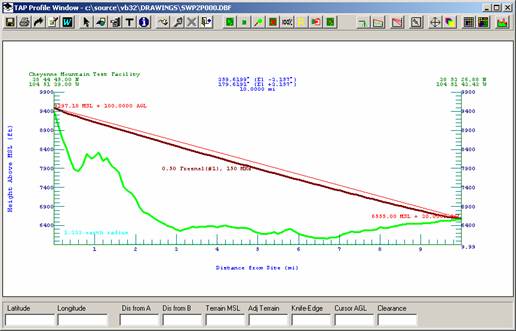
Cheyenne Mountain Test Facility: 38 44 45.00 N 104 51 39.00 W
Frequency: 150.00000 MHz ERP: 100.0000 W
Arbitrary Point 10mi, 359T: 38 53 26.88 N 104 51 43.43 W
Path: 10.0000 mi; Azimuth 359.6196
Step: 0.1000 mi; Effective Earth Curvature: 1.333
Topo Data:
Interpolation: FCC Interpolation (4 points)
TX Site MSL adjusted to: 9397.18 ft
TX Ant: 9497.18ft MSL (Site 9397.18ft + 100.00ftAGL)
RX Site MSL adjusted to: 6554.76 ft
RX Ant: 6584.76ft MSL (Site 6554.76ft + 30.00ftAGL)
Azimuth: 359.620
TX Antenna Gain: Az 0.00 dB; El 0.00 dB (angle = -3.157)
Free Space Field: (100.000 W @ 10.000 mi) 72.79 dBu
Free Space Loss: 95.82 dB (between dipoles)
Additional Estimated transmission loss :0.00 dB
Line-of-sight path
LR Mode: 11
Individual; No Location Var
Polarization: V
Surface Refrac: 0.00(300.90)
Permittivity: 15.00 Conductivity: 0.0050
Climate: Continental Temperate
Path terrain Delta-H: 2915.77 ft
Effective antenna heights: 2076.75 ft 716.25 ft
|
|
50.0% Time |
90.0% Time |
99.9% Time |
|
50.0% Situation |
72.8 |
72.7 |
72.6 |
|
90.0% Situation |
62.9 |
62.8 |
62.7 |
|
99.9% Situation |
48.9 |
48.8 |
48.7 |
Sample Path 3
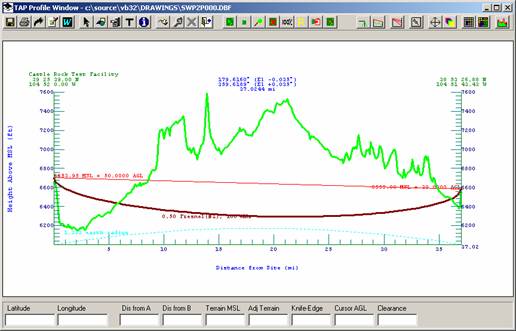
Castle Rock Test Facility: 39 25 39.00 N 104 52 0.00 W
Frequency: 150.00000 MHz ERP: 100.0000 W
Arbitrary Point 10mi, 359T: 38 53 26.88 N 104 51 43.43 W
Path: 37.0244 mi; Azimuth 179.6160
Step: 0.1000 mi; Effective Earth Curvature: 1.333
Topo Data:
Interpolation: FCC Interpolation (4 points)
TX Site MSL adjusted to: 6653.95 ft
TX Ant: 6703.95ft MSL (Site 6653.95ft + 50.00ftAGL)
RX Site MSL adjusted to: 6555.95 ft
RX Ant: 6585.95ft MSL (Site 6555.95ft + 30.00ftAGL)
Azimuth: 179.616
TX Antenna Gain: Az 0.00 dB; El 0.00 dB (angle = -0.035)
Free Space Field: (100.000 W @ 37.024 mi) 61.42 dBu
Free Space Loss: 107.19 dB (between dipoles)
Additional Estimated transmission loss :61.40 dB
Double-horizon path Diffraction
LR Mode: 11
Individual; No Location Var
Polarization: V
Surface Refrac: 0.00(300.90)
Permittivity: 15.00 Conductivity: 0.0050
Climate: Continental Temperate
Path terrain Delta-H: 1141.40 ft
Effective antenna heights: 739.31 ft 194.07 ft
|
|
50.0% Time |
90.0% Time |
99.9% Time |
|
50.0% Situation |
25.6 |
23.8 |
21.3 |
|
90.0% Situation |
16.9 |
15.1 |
12.4 |
|
99.9% Situation |
4.6 |
2.7 |
0.02 |
Sample Path 4
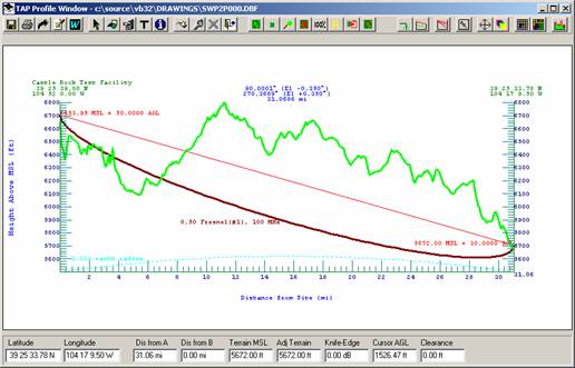
Castle Rock Test Facility: 39 25 39.00 N 104 52 0.00 W
Frequency: 100.00000 MHz ERP: 100.0000 W
Test site: 39 25 33.78 N 104 17 9.50 W
Path: 31.0686 mi; Azimuth 90.0001
Step: 0.1000 km; Effective Earth Curvature: 1.333
Topo Data: 30-second
Interpolation: FCC Interpolation (4 points)
Longley-Rice: LR 50 50
TX Site MSL adjusted to: 6653.95 ft
TX Ant: 6703.95ft MSL (Site 6653.95ft + 50.00ftAGL)
RX Site MSL adjusted to: 5672.44 ft
RX Ant: 5970.44ft MSL (Site 5672.44ft + 298.00ftAGL)
Azimuth: 90.000
TX Antenna Gain: Az 0.00 dB; El 0.00 dB (angle = -0.256)
Free Space Field: (100.000 W @ 31.069 mi) 62.94 dBu
Free Space Loss: 102.15 dB (between dipoles)
Additional Estimated transmission loss :28.50 dB
Double-horizon path Diffraction
LR Mode: 11
Individual; No Location Var
Polarization: V
Surface Refrac: 0.00(300.90)
Permittivity: 15.00 Conductivity: 0.0050
Climate: Continental Temperate
Confidence: 50.00 Reliability: 50.00
Path terrain Delta-H: 728.94 ft
Effective antenna heights: 359.98 ft 298.00 ft
|
|
50.0% Time |
90.0% Time |
99.9% Time |
|
50.0% Situation |
34.4 |
33.1 |
31.3 |
|
90.0% Situation |
25.5 |
24.2 |
22.3 |
|
99.9% Situation |
12.98 |
11.7 |
9.7 |
Sample Path 5
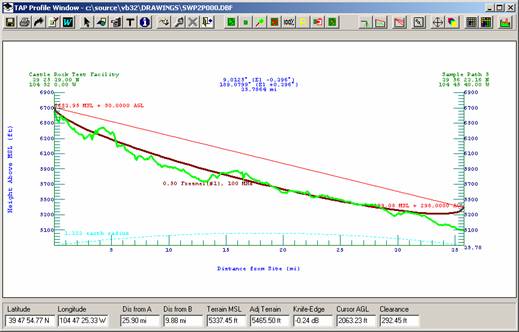
Castle Rock Test Facility: 39 25 39.00 N 104 52 0.00 W
Frequency: 100.00000 MHz ERP: 100.0000 W
Target site from map: 39 56 23.16 N 104 45 40.00 W
Path: 35.7864 mi; Azimuth 9.0125
Step: 0.1000 km; Effective Earth Curvature: 1.333
Topo Data: 30-second
Interpolation: FCC Interpolation (4 points)
Longley-Rice: LR 50 50
TX Site MSL adjusted to: 6653.95 ft
TX Ant: 6703.95ft MSL (Site 6653.95ft + 50.00ftAGL)
RX Site MSL adjusted to: 5099.08 ft
RX Ant: 5397.08ft MSL (Site 5099.08ft + 298.00ftAGL)
Azimuth: 9.012
TX Antenna Gain: Az 0.00 dB; El 0.00 dB (angle = -0.396)
Free Space Field: (100.000 W @ 35.786 mi) 61.71 dBu
Free Space Loss: 103.37 dB (between dipoles)
Additional Estimated transmission loss :9.97 dB
Line-of-sight path
LR Mode: 11
Individual; No Location Var
Polarization: V
Surface Refrac: 0.00(300.90)
Permittivity: 15.00 Conductivity: 0.0050
Climate: Continental Temperate
Confidence: 50.00 Reliability: 50.00
Path terrain Delta-H: 360.77 ft
Effective antenna heights: 408.37 ft 424.18 ft
|
|
50.0% Time |
90.0% Time |
99.9% Time |
|
50.0% Situation |
51.7 |
50.2 |
48.2 |
|
90.0% Situation |
42.9 |
41.4 |
39.21 |
|
99.9% Situation |
30.5 |
28.9 |
26.7 |
|
|
Copyright 2004 by SoftWright LLC