Notes on Longley-Rice
Propagation
Notes on The Prediction of Tropospheric Radio Transmission
Loss Over Irregular Terrain (the Longley-Rice Model)
Overview
This document describes the assumptions and methods used in
SoftWright's implementation of the "Longley-Rice" point-to-point
model for radio propagation in the Terrain Analysis Package (TAP).
The Longley-Rice model predicts long-term median transmission
loss over irregular terrain relative to free-space transmission
loss. The model was designed for frequencies between 20 MHz and
40 GHz and for path lengths between 1 km and 2000 km.
Note that SoftWright has implemented the "point-to-point"
mode rather than the "area" mode because required path-specific
parameters can be determined from detailed terrain path profiles
available in TAP. The point-to-point mode implemented by SoftWright
uses detailed terrain profiles to determine the distances to radio
horizons, the horizon elevation angles and effective antenna heights
needed by the model. As with other SoftWright propagation models,
coverage studies of large areas are accomplished using a large
number of individual path studies to multiple points along multiple
radials from the central transmitting site.
This implementation is based on Version 1.2.2 of the model,
dated September 1984. A later series (beginning with Version 2.0,
dated May 1970) uses "considerably modified diffraction calculations"
and is "not now recommended and is no longer maintained by
its developers." ("A Guide to the Use of the ITS Irregular
Terrain Model in the Area Prediction Mode", NTIA Report 82-100,
page 17). Note also that the version 1.2.2 implemented by SoftWright
does not utilize several other corrections to the model proposed
since the method was first published (see A. G. Longley, "Radio
propagation in urban areas," OT Rep. 78-144, Apr. 1978; and
A. G. Longley, "Local variability of transmission loss- land
mobile and broadcast systems," OT Rep., May 1976).
Technical Foundation
TAP users should consult the following technical publications
for a detailed discussion of the theoretical and empirical bases
of the model:
"Tech Note 101": P. L. Rice, A. G. Longley, K. A.
Norton, and A. P. Barsis, "Transmission loss predictions
for tropospheric communication circuits," U.S. Government
Printing Office, Washington, DC, NBS Tech. Note 101, issued May
1965; revised May 1966 and Jan. 1967.
"Longley-Rice": A. G. Longley and P. L. Rice, "Prediction
of Tropospheric radio transmission over irregular terrain, A Computer
method-1968." ESSA Tech. Rep. ERL 79-ITS 67, U.S. Government
Printing Office, Washington, DC, July 1968.
"NTIA Report": G. A. Hufford, A. G. Longley, and
W. A. Kissick, "A guide to the use of the ITS irregular terrain
model in the area prediction mode," NTIA Rep. 82-100, Apr.
1982.
"ITS Report": "Telecommunications Analysis Services
Reference Guide", Institute for Telecommunications Services,
Spectrum Division, Dec 7, 1983.
A brief but helpful overview of the model, as well as a comparison
to other models, is found in IEEE publication "Coverage Prediction
for Mobile Radio Systems Operating in the 800/900 MHz Frequency
Range," IEEE Trans. Vehicular. Technology, vol. VT-37, p.
21, 27-35, 1988.
Implementation
The SoftWright implementation of the Longley-Rice model preserves
the methods and calculations of the original Version 1.2.2 source
code, and, as much as possible, integrates the model into the
existing Terrain Analysis Package (TAP) software system. However,
as described, below, certain constraints imposed by the Longley-Rice
model require slight modifications in the use of the TAP system.
These modifications are thoroughly discussed below.
General Parameters
Like the other models available in the TAP system (e.g., Carey,
Bullington, Okumura) the Longley-Rice model requires the input
of certain general parameters to set up the program for propagation
calculations:
Frequency The nominal frequency range
for the Longley-Rice model is listed as 20 MHz to 40 GHz in the
original paper. The upper limit is modified to 20 GHz in some
later documentation.
ERP Effective Radiated Power is entered in the units set by
the user in the System Configuration Screen (mW, W, kW, dBm,
dBW, dBk).
Antenna Omni-directional transmitter operation is assumed
unless a directional antenna is specified.
Heights Antenna heights above ground for transmit and receive
facilities are entered in the user-specified units (feet or meters).
The program will compute the effective heights needed for Longley-Rice
calculations.
Longley-Rice Parameters
The nature of the Longley-Rice model requires certain additional
parameters:
Polarization: Either horizontal or vertical
polarization must be specified. The Longley-Rice model assumes
that both antennas have the same polarization, either vertical
or horizontal.
Refractivity: The refractivity of the atmosphere determines
the amount of "bending" of the radio waves. In other
TAP models, the effect of refractivity is entered as effective
earth curvature, typically "4/3 earth" (1.333). In
the Longley-Rice model, there are three ways of specifying refractivity:
You can enter the "Surface Refractivity" value directly,
typically in the range of 250 to 400 N-units (corresponding to
earth curvature values from 1.232 to 1.767). An effective earth
curvature of 4/3 (=1.333) corresponds to a surface refractivity
value of approximately 301 N-units. Longley and Rice recommend
an Ns equal to 301 N-units for average atmospheric conditions.
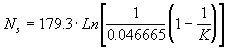
You can enter the effective earth curvature value K (such
as 1.333 for 4/3 earth) and the surface refractivity Ns will
be computed from:
You can enter the refractivity referenced to sea level No
and the surface refractivity Ns will be computed based on the
elevation of the path. Values of No can be read from maps, such
as Figure 1 on page 5 of the 1968 Longley-Rice paper.
Permittivity: The relative permittivity (e
) or dielectric constant of the ground. Typical values are shown
below.
Conductivity The soil conductivity (in Siemens per meter)
of the ground. Typical values are shown below.
|
Relative Permittivity |
Conductivity (Siemens per meter) |
|
Average ground |
15 |
0.005 |
|
Poor ground |
4 |
0.001 |
|
Good ground |
25 |
0.020 |
|
Fresh water |
81 |
0.010 |
|
Sea water |
81 |
5.000 |
|
1 |
Equatorial (Congo) |
|
2 |
Continental Subtropical (Sudan) |
|
3 |
Maritime Subtropical (West coast of Africa) |
|
4 |
Desert (Sahara) |
|
5 |
Continental Temperate |
|
6 |
Maritime Temperate, over land (United Kingdom and continental
west coasts) |
|
7 |
Maritime Temperate, over sea |
According to Longley & Rice, "The
Continental Temperate climate is common to large land masses
in the temperate zone. It is characterized by extremes of temperature
and pronounced diurnal and seasonal changes in propagation. In
mid-latitude coastal areas where prevailing winds carry moist
maritime air inland, a Maritime Temperate climate prevails. This
situation is typical of the United Kingdom and of the west coasts
of the United States and Europe. For paths that are less than
100 km long, there is little difference between the Continental
and Maritime Temperate climates, but for longer paths the greater
occurrence of super refraction and ducting in maritime areas
may result in much higher fields for periods of 10 percent or
less of the year." (see NTIA Report)
Variability: Longley-Rice defines four modes of variability.
The mode selected determines the meaning of the reliability and
confidence values used in the model. The mode of variability
can be considered the "point of view" for considering
the meaning of "reliability" and "confidence"
in the calculations.
The modes of variability defined by Longley-Rice are: Single
message mode, Individual mode, Mobile mode, and Broadcast mode.
These modes are defined in more detail in NTIA, p. 37.
In earlier versions of the SoftWright implementation (up to
and including TAP 4.0) all calculations use the point-to-point
mode of Longley-Rice to compute the field at individual locations
(multiple points along multiple radials from a transmitter site).
Therefore, the mode of variability was fixed as "Individual"
mode (called "Accidental" mode in some of the literature).
Furthermore, since we are exactly defining the receive location
for each calculation, the program did not consider location variability.
Beginning with TAP 4.1, both the mode of variability and the
option for location variability can be selected by the user.
The default values for these parameters are "Individual"
and "Ignore Location Variability" for compatibility
with the earlier versions of TAP.
The types of variability described in Longley-Rice are time,
location, and situation variability. These three "dimensions
of variability" were developed to account for and categorize
variations in measured median signal levels (see NTIA Report,
pp. 28-31): (Note that short term variability of the type associated
with multipath propagation is not covered by the model.)
Time variability accounts for variations of hourly
median values of attenuation due to, for example, slow changes
in atmospheric refraction or in the intensity of atmospheric
turbulence. The computed field strength value is an hourly median
value; the actual field strength at the receiver location would
be expected to be above that value during half of each hour and
below that value for half of each hour. Time variability describes
the effects of these changes over time. The time variability
for the calculation is expressed as a percentage from 0.1% to
99.9%. This value gives the fraction of time during which actual
received field strength is expected to be equal to or higher
than the hourly median field computed by the program. This variable
allows you to specify how you want to deal with the time variability
of changing atmospheric (and other) effects as described above.
Entering higher percentage reliability values effectively reduces
the variability resulting from these factors. The resulting field
strength predicted by the program will be lower, but with increased
reliability that the actual field that could be measured would
equal or exceed the computed value at any given time.
Location variability accounts for variations in long-term
statistics that occur from path to path due to, for example,
differences in the terrain profiles or environmental differences
between the paths. The location variability for the calculation
is expressed as a percentage from 0.1% to 99.9%. This value gives
the fraction of locations where actual received field strength
is expected to be equal to or higher than the median field computed
by the program. This variable allows you to specify how you want
to deal with the location variability. Entering higher percentage
reliability values effectively reduces the variability resulting
from these factors. The resulting field strength predicted by
the program will be lower, but with increased reliability that
the actual field that could be measured would equal or exceed
the computed value at any given time.
Situation variability accounts for variations between
"like appearing" (NTIA, p. 30) systems with the same
system parameters and environmental conditions, including differences
in the ability of individuals to accurately take field strength
readings. "It is at this point that 'hidden variables' enter,
variables whose effects we do not understand or which we simply
have not chosen to control. The values of these variables are
at the whim of nature and differ between what would otherwise
be identical situations. The effects of these differences produce
the changes in observed statistics" (NTIA, p.30). Situation
variability describes the effects of the changing conditions
resulting from these "hidden variables." The situation
variability for the calculation is expressed as a percentage
from 0.1% to 99.9%. This value gives the fraction of "identical"
paths on which actual received field strength is expected to
be equal to or higher than the field computed by the program.
This variable allows you to specify how you want to deal with
the "hidden variables" that are "at the whim of
nature" as described above. Entering higher percentage confidence
values effectively reduces the variability resulting from these
factors. The resulting field strength predicted by the program
will be lower, but with increased confidence that the actual
field that could be measured would equal or exceed the computed
value.
In the default settings of the SoftWright implementation of
Longley-Rice, these dimensions of variability are expressed in
terms of "reliability" and "confidence".
The terms are introduced in the NTIA Report at 36. According
to this report, reliability refers to a measure of the variability
that a radio system will observe during its use. Confidence refers
to the variability that remains after specifying reliability,
measurable in the aggregate of a large number of radio systems.
Terrain Profile Characteristics
The Longley-Rice model, as implemented by SoftWright, uses
the elevation values to create a detailed profile of a path for
analysis by the program. In the case of the Longley-Rice program,
the elevation values are read from the TAP elevation data base.
As with other propagation models in the TAP system, the file can
contain multiple radials and path studies can be performed for
multiple points along each radial.
Note that the model as it was originally designed expects terrain
profile information at equal increments along a specific path.
Although other propagation models available in the TAP system
permit unequal elevation point spacing (such as when a radial
elevation data file is edited to insert a particular peak or ridge),
such files pose a potential problem for the Longley-Rice program.
Elevation data extraction parameters that are specified for use
with the Longley-Rice field calculation program are first read
to determine compliance with the uniform spacing requirement.
(The spacing of elevation points on different radials does not
have to be the same, but the spacing between points on any given
radial must be uniform.) The spacing between points is assumed
to be the distance from the site to the first elevation point
on the radial. Any intermediate points (i.e., successive points
spaced at less than that distance from the preceding point) that
are found are ignored. If the spacing between successive points
is greater than the determined uniform spacing any remaining elevation
data on the radial cannot be processed by the model and that portion
of the radial is skipped. The program will compute field strength
values out to the last uniformly spaced point on the radial.
Path Parameter Calculations
1. Effective Antenna Heights: Effective antenna height is defined
as the height of the antenna above the "effective reflecting
plane" (see IEEE at 28). The model first determines a "range
of interest" based upon above ground elevation and the horizon
distance of each antenna, and then uses one of two methods to
determine the effective heights from the ground levels and least
squares elevation values.
2. Horizon Distances and Elevation Angles: The horizon elevation
angle refers to the angle by which the horizon rays are elevated
or depressed relative to the horizontal at each antenna (see Longley-Rice
at 3-1). Using detailed terrain profile information, the model
calculates horizon elevation angles as a function of antenna heights
above sea level, the effective earth's radius and the great circle
distances from each antenna to its horizon.
3. Terrain Irregularity: The model first uses linear interpolation
to fit a straight line within the range of interest and then determines
an interdecile range D h(d) above and
below this line (see IEEE at 28). The terrain irregularity parameter
D h is then computed.
4. Reference Attenuation: The horizon elevations and distances
generated by the model are used to calculate transmission loss
relative to free space. The model divides total transmission loss
into "free-space basic transmission loss" and reference
attenuation relative to free space. The free-space basic transmission
loss is calculated as a function of frequency and distance. The
net received field at any point is computed from the free-space
field reduced by the computed reference attenuation relative to
free space. One of three prediction methods described in Annex
3 of Longley-Rice is used to calculate the reference attenuation
based upon the distance from the transmitting antenna.
- Line of Sight Attenuation: Within radio line of sight, attenuation
relative to free space is calculated using two-ray optics formulas.
- Diffraction Attenuation: A diffraction method is used just
beyond line of sight that computes a weighted average of estimates
of diffraction attenuation over a double knife edge and over
irregular terrain.
- Forward Scatter Attenuation: Forward scatter attenuation
is computed when the path length and/or the angular distance
exceeds certain limits determined by the model.
Parameter Checking
The Longley-Rice programs described in NTIA and other literature
include validation of various parameters. The warnings are categorized
into four "levels" according to the severity of the
error:
Level |
Description (NTIA, p. 70) |
|
1 |
Caution, parameters are close to limits |
|
2 |
Impossible parameters; default values have been substituted |
|
3 |
Internal calculations show parameters out of range |
|
4 |
Parameters out of range |
The level recorded by the program is cumulative in the sense
that if both a level 1 error and a level 3 error are encountered,
the error reported is level 3.
Examples of the warnings detected in the Longley-Rice model
help to illustrate these levels:
Level |
Example of the warning |
|
1 |
A specified frequency below 40MHz is "close to limits"
of stated Longley-Rice range of 20 - 40GHz. |
|
2 |
A climate code of -1 is an "impossible parameter" since
the range is 1-7. A default value of 5 ("continental temperate")
will be substituted. |
|
3 |
Internal calculations based on the path elevation data can show
that a horizon elevation angle is beyond the range considered
valid for the Longley-Rice calculations. |
|
4 |
A specified frequency below 20MHz is "out of range"
since the stated Longley-Rice range is 20 - 40GHz. |
The original Longley-Rice programs include the following messages
for the warnings:
Level |
Message |
|
1 |
**WARNING - SOME PARAMETERS ARE NEARLY
OUT OF RANGE. RESULTS SHOULD BE USED WITH CAUTION. |
|
2 |
**NOTE - DEFAULT PARAMETERS HAVE BEEN
SUBSTITUTED FOR IMPOSSIBLE ONES. |
|
3 |
**WARNING - A COMBINATION OF PARAMETERS
IS OUT OF RANGE. RESULTS ARE PROBABLY INVALID. |
|
4 |
**WARNING - SOME PARAMETERS ARE OUT
OF RANGE. RESULTS ARE PROBABLY INVALID. |
These rather brief and general messages represent a number
of different conditions. The SoftWright implementation of the
Longley-Rice model expands these messages to include more information
about the specific condition that resulted in the warning level
set by the program. If more than one warning or error was encountered,
all messages will be recorded as described later in this section.
The SoftWright messages are listed below.
Detailed Message |
Level |
|
Horizon distance(s) may be too short.1 |
3 |
|
Horizon distance(s) may be too long.2 |
3 |
|
Horizon elevation angle greater than 11.5 degrees.3 |
3 |
|
Frequency below 40 MHz. |
1 |
|
Frequency above 10 GHz. |
1 |
|
Antenna height(s) less than 1 meter AGL. |
1 |
|
Antenna height(s) greater than 1000 meters AGL. |
1 |
|
Surface refractivity below 250. |
4 |
|
Surface refractivity above 400. |
4 |
|
Earth curvature less than 75E-9. |
4 |
|
Earth curvature greater than 250E-9. |
4 |
|
Real surface transfer impedance less than imaginary part. |
4 |
|
Frequency below 20 MHz. |
4 |
|
Frequency above 20 GHz. |
4 |
|
Antenna height(s) less than .5 meter AGL. |
4 |
|
Antenna height(s) greater than 3000 meters AGL. |
4 |
|
Distance for calculation is greater than 1000 km. |
1 |
|
Distance less than 5x difference between eff ant heights.4 |
3 |
|
Distance for calculation is less than 1 km. |
4 |
|
Distance for calculation is greater than 2000 km. |
4 |
|
Invalid climate code; climate code set to 5. |
2 |
|
Invalid variability mode; mode set to 0. |
2 |
|
Time probability set less than 0.1%. |
1 |
|
Location probability set less than 0.1%. |
1 |
|
Situation probability set less than 0.1%. |
1 |
Notes:
1 This condition occurs in Longley-Rice if the computed horizon
distance is less than:

where HE is the computed effective antenna height of the antenna
GME is the effective earth curvature
2 This condition occurs in Longley-Rice if the computed horizon
distance is less than:

where HE is the computed effective antenna height of the antenna
GME is the effective earth curvature
3 This condition occurs in Longley-Rice if the computed horizon
elevation angle is greater than 0.2 radians (11.5°).
4 This condition occurs in Longley-Rice if the distance for
the computed field strength is less than:
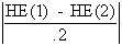
where HE(1) is the computed effective antenna height of the TX
antenna
HE(2) is the computed effective antenna height of the TX antenna
Whenever the Longley-Rice program encounters any of these conditions
the warning(s) are recorded in the TAP Results Data Base file
for the study.
Conclusion
The discussion in this article is intended to be a cursory
overview of the model's treatment of the parameters and statistics
of radio propagation as treated by the Longley-Rice model. You
are encouraged to refer to the literature to develop your own
understanding and interpretation of the Longley-Rice concepts.
Given your system parameters and statistical choices that you
have supplied in TAP's Longley-Rice module, our implementation
of the model will generate a file of field strength values computed
from the long-term median transmission losses at each increment
and along each radial you have selected. This file can then be
used just as other TAP field strength files with TAP's graphical
features (such as the threshold plotting).
Ordering Information For Longley-Rice
Propagation Model Documentation
The following documents are available from National Technical
Information Service (phone 1-800-553-6847, or 1-703-487-4656).
The abbreviated titles refer to the notation used for the documents
in the Terrain Analysis Package (TAP)™ Technical Reference
Manual section on the Longley-Rice model.
"Tech Note 101": P. L. Rice, A. G. Longley, K. A.
Norton, and A. P. Barsis, "Transmission loss predictions
for tropospheric communication circuits," U.S. Government
Printing Office, Washington, DC, NBS Tech. Note 101, issued May
1965; revised May 1966 and Jan. 1967.
Volume 1: Order Number AD687820
Volume 2: Order Number AD687821
"Longley-Rice": A. G. Longley and P. L. Rice, "Prediction
of Tropospheric radio transmission over irregular terrain, A
Computer method-1968." ESSA Tech. Rep. ERL 79-ITS 67, U.S.
Government Printing Office, Washington, DC, July 1968.
Order Number AD676874
"NTIA Report": G. A. Hufford, A. G. Longley, and
W. A. Kissick, "A guide to the use of the ITS irregular
terrain model in the area prediction mode," NTIA Rep. 82-100,
Apr. 1982.
Order Number PB 82 217 977
 |
I'm interested!
Please click here to jump to an online form which
helps us better understand your needs. Then we will be able to
respond to your request with information that is most useful
to you. |
Search SoftWright Website
Copyright 2000 by SoftWright LLC