TAP6 Surface Features and Land Use Data on Profiles
Q: Can I use the Land Use files to create Surface Feature files for use in TAP6 on a path profile?
A: Both the Land Use files and the Surface Feature files add information to the basic topographic elevation data, and both are important for creating realistic path profiles, area coverage studies, etc. This article also describes how to add Surface Feature objects graphically from a path profile.
Note that all values in this example are for demonstration purposes only. You should determine appropriate settings for your application.
First, it is important to understand the difference between how the types of files are used in TAP.
Land Use files (from the USGS or created with the Land Used Editor in TAP) contain information about the type of use of the land, such as agricultural, forested, residential, industrial, urban, etc. The primary use of these files in TAP is to apply a user-defined loss value for a field strength calculation, based on the land use classification at the receiver location. For example, suppose the computed field value at a location is 50dBu. If the location is an open field in an agricultural area, you would expect no significant additional losses. But if the location is in a heavily industrialized urban area, the additional losses from buildings and man-made noise might make the signal unusable. The Land Use module includes the ability to assign loss values based on different use classifications as a function of frequency.
The Surface Feature files (also called Obstruction files in earlier versions of TAP) serve a different function. These files enable you to define three-dimensional obstacles at a specified location and with a specified height. These obstacles are then used in path profiles or field strength calculation by adding the obstacle height to the topographic elevation data. For example, a path that has unobstructed line of sight over a ridge in the topography might not have line of sight if 50 foot buildings are added as a Surface Feature on the topography. The addition of the obstruction will be considered in the field strength calculation. The terrain elevation values will be augmented by the obstruction height before the line-of-sight and loss calculations are computed.
In summary, the Land Use files affect the calculation specifically at the receiver location, and the Surface Feature files affect the calculation along the path.
The Land Use files do not include height information, so a classification of "Forest" does not indicate if the trees are 20 feet or 100 feet tall. Also, the Land Use files are typically on a 200 meter grid, with groupings of use classifications forming arbitrary shapes. Since the Surface Feature files require height information, and are defined as circular area approximations, there is not a convenient way to automate the conversion of Land Use information to Surface Feature files.
However, you can use the Land Use information as a guideline for creating Surface Feature files.
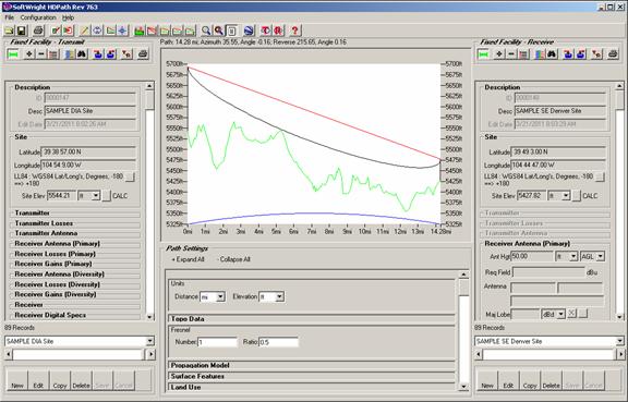
Consider a sample path between two specified coordinates as shown:
The path has clear line of sight, and only minimal Fresnel zone clearance. The initial evaluation would be that this is likely a usable path, even at the 952Mhz frequency shown on the profile.
In order to determine if ground clutter might be a factor on this path, we can add Land Use information by checking the “Include Land Use Data” box in the Land Use section of the HDPath form:
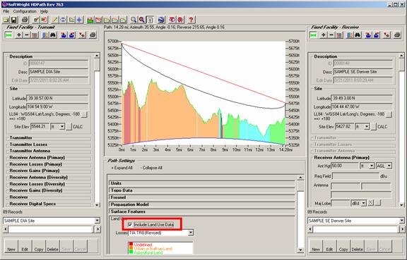
The program will retrieve the Land Use classification values for each point along the path and display the different values as different colors below the terrain profile.
The Land Use data shows "Urban or Built-up land" for most of the first half of the path, but a mixture of agricultural and rangeland areas farther out on the path.
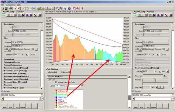
In this example, it would make sense to add some Surface Feature obstacles to represent the urban buildings. The agricultural and rangeland will likely have little obstructing effect on the path.
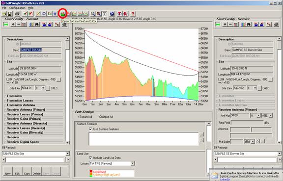
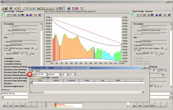
To add surface features to the profile, click the “Open Surface Feature Editor” button on the toolbar (the icon with a green profile with red obstacles shown):
Note that the list of Surface Feature files in the “Surface Features” section of the HDPath form is empty. If you add existing files to the list (using the “…” button) you can add objects to an existing file as described below if you first select the file in the list before clicking the “Open Surface Feature Editor” button. In this example we will create a new file.
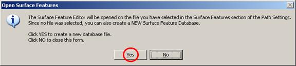
On the “Open Surface Features” dialog box, click the Yes button to create a new file:
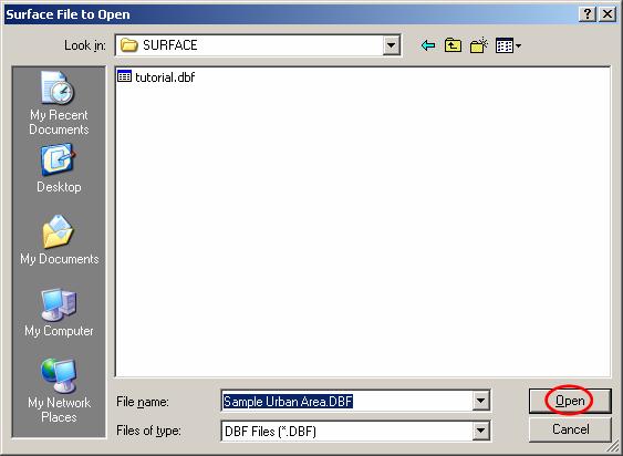
The default location for Surface Feature files is the SURFACE folder where TAP is installed. Enter a name for the file you want to create and click the Open button:
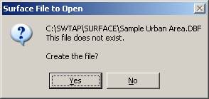
You will be prompted to create a new file?
The Surface Feature editor will be displayed:
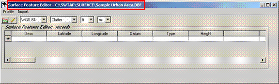
Since the TAP Profile Window is displayed, the Surface Feature editor includes the Profile Selection options. The "Add from profile" button enables you to draw an area on the profile to define a Surface Feature obstacle.
Be sure the “Surface Feature Editor” form is not covering the path profile on the HDPath form, then click the "Add from profile" button.
You will be prompted to draw an area on the profile by clicking two opposite corners. Draw a box that encloses the Land Use area shown in red, approximating the vertical height of 40 feet.
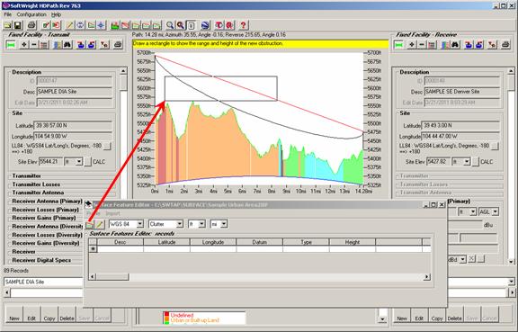
The vertical location of the box is not critical, and you will be approximating the height (to be corrected below). The horizontal location of the box will define the limits of the obstruction along the path.
When you release the mouse, the obstruction will be added to the database and drawn on the profile:
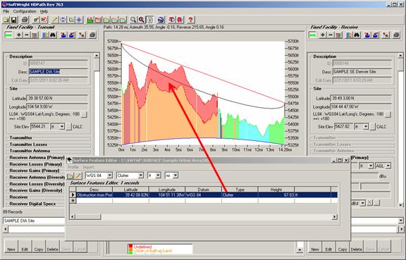
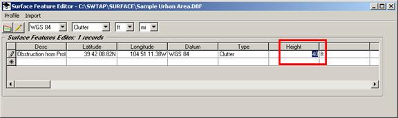
The height of the obstruction will be based on the arbitrary height of the box you drew on the profile. To correct the height to the desired value, edit the “Height” value in the Surface Feature Editor:
You can also edit the Description of the object you added:
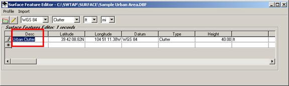
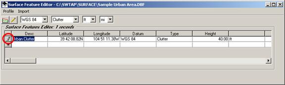
Note that when you edit a row in the Surface Feature Editor, the edit status is indicated by the pencil icon on the selection button at the left end of the row.
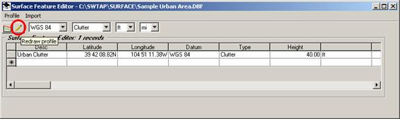
Move the mouse cursor off of the row you are editing to complete the edit. The pencil icon will disappear. Click the “Redraw Profile” button.
The edited height will be applied to the object on the path profile:
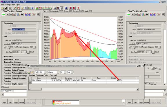
Now that the Surface Feature obstacle (representing the 40 foot buildings in the area) has been added, the suitability of the path is now questionable based on this more complete information.
|
|
Copyright 2011 by SoftWright LLC