Global Land Cover and USGS Classifications
Q: How do I change the default associations between the Global Land Cover values and the USGS Land Use classifications?
A: With TAP6.0.2203 or later, the Land Use module, and a Maintenance Subscription date of December 31, 2007, or later, you can use Global Land Cover (GLC) data files with TAP.
Note that all values in this example are for demonstration purposes only. You should determine appropriate settings for your application.
To use the GLC files with TAP you will need to set the configuration for the file locations.
The GLC data provides a classification for each 30x30-arcsecond grid point. The data contains 14 numeric classifications:
|
0 |
Water |
|
1 |
Evergreen Needleleaf Forest |
|
2 |
Evergreen Broadleaf Forest |
|
3 |
Deciduous Needleleaf Forest |
|
4 |
Deciduous Broadleaf Forest |
|
5 |
Mixed Forest |
|
6 |
Woodland |
|
7 |
Wooded Grassland |
|
8 |
Closed Shrubland |
|
9 |
Open Shrubland |
|
10 |
Grassland |
|
11 |
Cropland |
|
12 |
Bare Ground |
|
13 |
Urban and Built-up |
TAP associates each GLC value with a corresponding USGS Land Use Classification value. The default values, along with the complete list of USGS classifications, are shown below:
|
GLC Numerical Value |
GLC Description |
USGS Numerical Value |
USGS Description |
|
13 |
Urban and Built-up |
10 |
Urban or Built-up Land Codes |
|
|
|
11 |
Urban: Residential |
|
|
|
12 |
Urban: Commercial and Services |
|
|
|
13 |
Urban: Industrial |
|
|
|
14 |
Urban: Transportation, Communications, and Utilities |
|
|
|
15 |
Urban: Industrial and Commercial Complexes |
|
|
|
16 |
Urban: Mixed |
|
|
|
17 |
Urban: Other |
|
|
|
20 |
Agricultural Land |
|
11 |
Cropland |
21 |
Agricultural: Cropland and Pasture |
|
|
|
22 |
Agricultural: Orchards, Groves, Vineyards, Nurseries, and Ornamental Horticultural Areas |
|
|
|
23 |
Agricultural: Confined Feeding Operations |
|
|
|
24 |
Agricultural: Other |
|
10 |
Grassland |
30 |
Rangeland |
|
|
|
31 |
Rangeland: Herbaceous |
|
8 9 |
Closed Shrubland Open Shrubland |
32 |
Rangeland: Shrub and Brush |
|
|
|
33 |
Rangeland: Mixed |
|
6 |
Woodland |
40 |
Forest Land |
|
3 4 |
Deciduous Needleleaf Forest Deciduous Broadleaf Forest |
41 |
Forest Land: Deciduous |
|
1 2 |
Evergreen Needleleaf Forest Evergreen Broadleaf Forest |
42 |
Forest Land: Evergreen |
|
5 7 |
Mixed Forest Wooded Grassland |
43 |
Forest Land: Mixed |
|
0 |
Water |
50 |
Water |
|
|
|
51 |
Water: Streams and Canals |
|
|
|
52 |
Water: Lakes |
|
|
|
53 |
Water: Reservoirs |
|
|
|
54 |
Water: Bays and Estuaries |
|
|
|
60 |
Wetland: |
|
|
|
61 |
Wetland: Forested |
|
|
|
62 |
Wetland: Nonforested |
|
12 |
Bare Ground |
70 |
Barren Land |
|
|
|
71 |
Barren Land: Dry Salt Flats |
|
|
|
72 |
Barren Land: Beaches |
|
|
|
73 |
Barren Land: Sandy Areas Other than Beaches |
|
|
|
74 |
Barren Land: Bare Exposed Rock |
|
|
|
75 |
Barren Land: Strip Mines, Quarries, and Gravel Pits |
|
|
|
76 |
Barren Land: Transitional Areas |
|
|
|
77 |
Barren Land: Mixed |
|
|
|
80 |
Tundra |
|
|
|
81 |
Tundra: Shrub and Brush Tundra |
|
|
|
82 |
Tundra: Herbaceous |
|
|
|
83 |
Tundra: Bare Ground |
|
|
|
84 |
Tundra: Wet |
|
|
|
85 |
Tundra: Mixed |
|
|
|
90 |
Perennial Snow or Ice |
|
|
|
91 |
Perennial Snow or Ice : Perennial Snowfields |
|
|
|
92 |
Perennial Snow or Ice: Glaciers |
From the table you can see that the USGS Classifications have numerous sub-codes and nuances of meaning. If you want to use any of these other USGS classifications, you can edit and change the default associations.
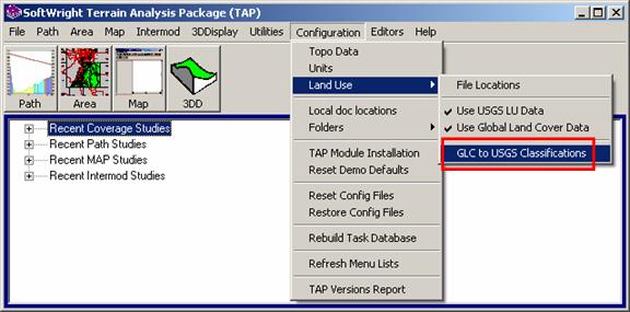
From the TAP6 Configuration menu click the “Land Use” item, then the “GLC to USGS Classifications” item:
The 14 GLC categories are shown on the left of the “GLC to USGS” form:
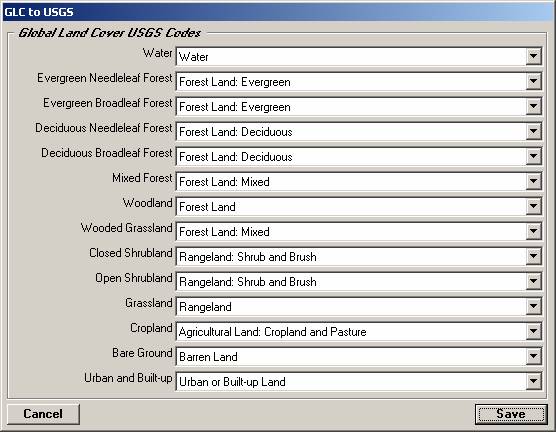
For each GLC item you can use the pull-down list to associate that GLC category with the desired USGS classification.
All Land Use functions (path profiles, area coverage studies, map layers) are affected by the settings in the “GLC to USGS” association form.
The association between the GLC values and the USGS values enables the GLC data to be used with TAP just as the USGS data. For example, the Loss Template values contain signal loss values as a function of frequency and USGS Land Use classifications. When the GLC data is used, the values are translated to the USGS value based on the associations defined, and the loss values are computed from those values.
|
|
Copyright 2007 by SoftWright LLC