Q: How do I set up a radial coverage study with radials of unequal length or spacing?
A: The "Basic" tab of the Area Coverage Setup form allows you to set up a radial study consisting of uniformly spaced, equal length radials. The "Advanced" tab gives you more flexibility for setting up several different types of radials with different lengths and spacings.
Advanced Tab
When the "Use Advanced Settings" box is checked, the Advanced tab is enabled, and the settings on that tab override the settings on the "Basic" tab.
Like the Basic tab, the Advanced tab is organized into several sections. The accessibility of some of the sections depends on the type of coverage study selected (on the Basic tab).
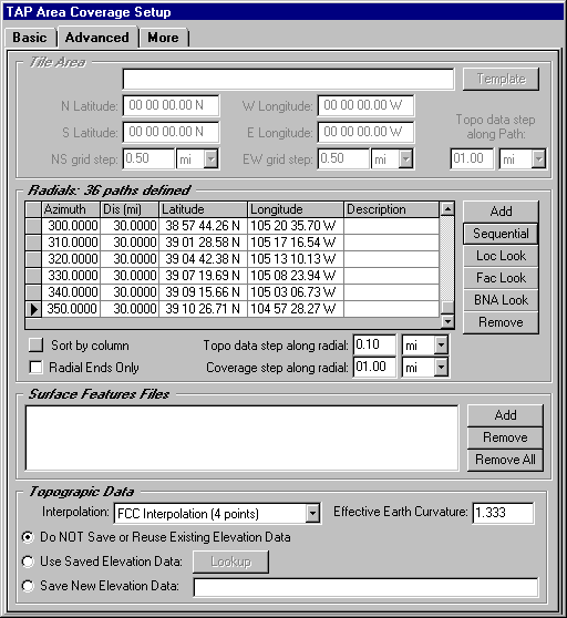
Radials
The radial or contour studies set up from the Basic tab allow uniformly spaced radials of equal length. If you want to specify non-uniform spacing, or unequal length radials, you can use the Advanced tab. (The Radials section is only accessible if you have selected the Radials or Contour option in the Coverage Area section on the Basic tab.)
The buttons in this section provide several ways to define radials:
The "Remove" button is used to remove lines from the radial list.
The "Radial Ends Only" box can be checked if you only want to compute the field at the end of each radial. For example, if you create radials for a list of sites in a .BNA file, you probably don’t care about the field along each path between the transmitter and the target point.
The "Distance between Points" sets the step for the field calculations along the radials for the radial or contour study.
You can use the "Sort by column" button to sort the list of radials. For example, if you want to view the radials for a .BNA file based on the length of each radial, click on the top of the Distance column to select that column, then the sort button
The Advanced tab also includes other functions.
Surface Feature Files
Use the "Add" button to lookup TAP Surface Feature files that can contain obstructions, vegetation, etc., to be used in the study.
Topographic Data
The Basic tab uses FCC four-point interpolation (described in the TAP Technical Reference Manual) to interpolate the required elevation data points from the topographic data files. You can select one of the other interpolation methods using the pulldown list. You can also set an effective earth curvature value.
Three options are available regarding saved topographic data.
Copyright 2000 by SoftWright LLC