
Path Profile in Google Earth
Q: How can I show a path profile in 3D using Google Earth?
A: With TAP6.0.2259, or later, including the 3DDisplay Module and a Maintenance Subscription date of September 30, 2008, or later, you can export path profile information to a .KML file for use with Google Earth.
Note that all values in this example are for demonstration purposes only. You should determine appropriate settings for your application.
You can use this functionality to export line of sight and Fresnel information for display in Google Earth, as well as for inspecting a Google Earth display for site elevation anomalies.
(Build 2342 includes additional options for improving the Google Earth export described in this FAQ.)
Note you can also draw multiple paths in Google Earth.
For example, suppose you have plotted a profile in HDPath as shown below:
Note that the “Bend Line of Sight” option is selected to include the effective earth curvature appearance in Google Earth. For more information, see the “Google Earth Path Configuration” article. That article also describes how to set the color and line width values exported to Google Earth.
Also note that if your profile is drawn showing multiple Fresnel zones or multiple earth curvatures, only the first value for each setting is exported. To export profile information for other settings, you can change the order of the Fresnel or curvature values.
Click the Google Earth button to create the file. You will be prompted for a file name:

Select the file name you want and click the Save button.
A form will be displayed indicating that the file is being created:

When the file is completed, Google Earth will be launched with the .KML file (if you have an internet connection and the Google Earth software installed):

You can use the Google Earth navigation controls in the upper right corner to zoom, pan, rotate, and tilt the image to view the path line of sight and Fresnel zone:
If you zoom straight down on the path, note that the Fresnel zone is plotted to the sides of the path as well as below it.

If you rotate and tilt the image, you can view the Fresnel zone limits below and to the sides of the line of sight. This is helpful to inspect areas of special interest along the path:
The Fresnel clearance below the line of sight may appear larger than the clearance to the sides because of the Google Earth “Tools|Options|Elevation Exaggeration” setting. This parameter in Google Earth is often helpful for a better view of the vertical terrain characteristics. The vertical Fresnel clearance will be adjusted by the same setting.
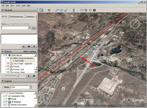
You can pan along different parts of the path to inspect areas of interest. For example, there is a significant obstruction at about 33 miles along the path as shown in HDPath:
Navigating the Google Earth image to the same location displays the obstacle:

While topographic elevation data files are typically very accurate, there are occasional anomalies. Likewise, if you have entered a site elevation incorrectly, the profile will not be an accurate representation of the path.
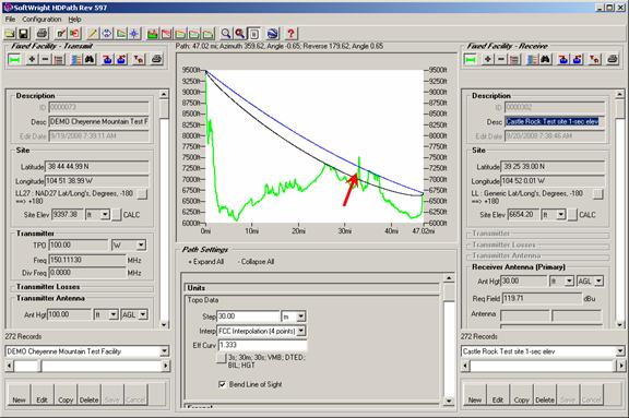
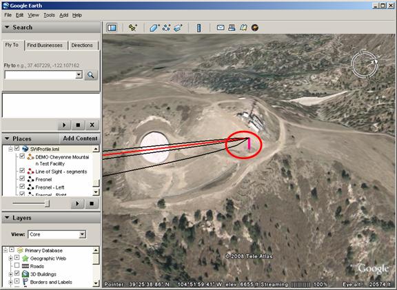
For example, suppose you have a Fixed Facility site record for Castle Rock with an estimated elevation that was entered manually:
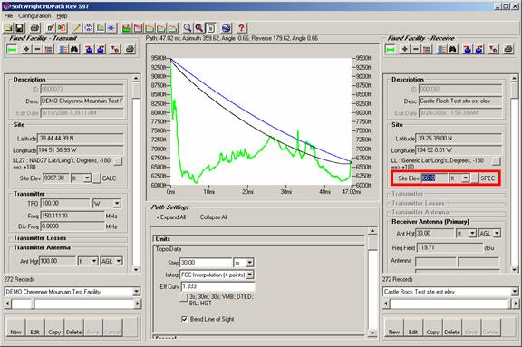
When you export the path to Google Earth and inspect the path, note the display at the Castle Rock site:

The site elevation estimate appears to be a bit low, given the fact that the line of sight to the antenna 30 feet up on the tower is buried in the ground.
Using a more accurate site elevation value, from the topographic elevation data (in this case, 1-second NED data) or a map or an accurate site survey will produce better results:
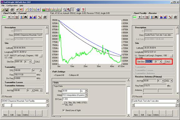
The Google Earth display reflects the improved accuracy of the site elevation:
|
|
Copyright 2008 by SoftWright LLC