Topo Data Names
Q: I want to select the data types for use with TAP, but the selection form has changed. How do I use that data?
A: With TAP6.0.2196 or later the form for selecting topo data types was changed to avoid confusion between different data formats and data sources.
Note that all values in this example are for demonstration purposes only. You should determine appropriate settings for your application.
In addition to the older data types (.DTA files from older versions of TAP), TAP 4.5 and later have used the TopoScript™ engine to read a variety of other data formats. These include:
· SRTM (Shuttle Radar Topography Mission) data in the .HGT file format
· NED (National Elevation Dataset) data in the .BIL format
· DTED (Digital Terrain Elevation Data) format in the .DT0, .DT1, etc., formats
Originally, these data types were closely associated with the source of the data:
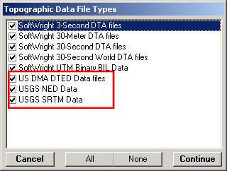
· SRTM data (.HGT files) from the U.S. Geological Survey
· NED data (.BIL files) from the U.S. Geological Survey
· DTED data (.DT0, .DT1, etc., files) from the Defense Mapping Agency
The types were selected for use in TAP using the “Topographic Data File Types” form:
As you can see, the data source (USGS, DMA) was closely associated with the format of data to be used (.BIL, .HGT, etc.).
As other data sources have become available, those sources have used some of the common file types supported by TAP. For example, “finished” SRTM data is now available in both the .BIL and DTED formats. Some users have access to custom elevation data in any of these formats.
This is a great benefit, providing TAP users access to additional data sources. But there was also a potential source of confusion: For example, What if I want to use data in the .BIL file format but the data did not come from the USGS NED?
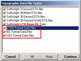
To clarify the situation, the “Topographic Data File Types” form was modified to indicate the format of the data to be selected (DTED, BIL, HGT files), not the source (DMA, NED, SRTM, etc.) of the data:
In most cases, selecting “All” data types is suggested, since TAP will find the highest resolution data available and use that elevation information.
In special cases where you want to use only certain data formats but distinguishing different sources, you can place different data into different folders and use the topo data indexing function to select the folders to read.
If you have questions, please contact SoftWright support.
|
|
Copyright 2007 by SoftWright LLC