TAP6 Surface Feature Import Format
Q: What file formats can I import into TAP6 Surface Feature files?
A: With TAP6.0.2150 or later and a Maintenance Subscription date of February28, 2007, or later, you can import Surface Feature files into TAP6.
The TAP Surface Feature function is used to add objects that represent additional elevation (above the topographic data values) on the surface of the ground, such as buildings, vegetation, clutter, etc.
The following table lists the fields that can be imported into the TAP Surface Feature files:
The imported file can be
· A dBase (.DBF) file using the "Field Name" column values in the table as the field names in the DBF file
· An Excel spreadsheet that contains the "Field Name" column values as the first row in each column of the spreadsheet
· A comma-delimited ASCII file containing the "Field Name" column values, separated by commas, as the first line in the file
The import function uses the Field Names from the table below to map the imported fields to the TAP database, so the order of the fields in the file (DBF, Excel, or ASCII) is not important.
Also, since the import function uses the Field Names, it is not necessary to import all of the fields. Missing fields will be ignored. Naturally, several fields are related (such as the height and the height units) and should either both be included or both be omitted. Note also that certain fields are essential to the proper operation of the Surface Feature function in TAP, as noted below.
The following fields are required for normal use of the TAP Surface Feature files. Importing files which do not contain valid entries for all these fields will cause unpredictable operation when you use the Surface Feature files in TAP:
|
Field Name |
Field Header |
Data Type |
Total Field Width |
Field Decimal Places |
Comments |
|
OBS_DESC |
Description |
STRING |
40 |
|
Your description of the object |
|
OBS_LAT |
Latitude |
DOUBLE |
14 |
9 |
Center point latitude |
|
OBS_LON |
Longitude |
DOUBLE |
14 |
9 |
Center point longitude |
|
OBS_DATUM |
Datum |
STRING |
13 |
|
Coordinate Datum: NAD
27 |
|
OBS_HGT |
Height |
DOUBLE |
10 |
4 |
Height of the object |
|
OBS_HGTUN |
|
STRING |
2 |
|
Height units: ft |
|
OBS_RADIUS |
Radius |
DOUBLE |
10 |
4 |
Radius of object |
|
OBS_RADUN |
|
STRING |
2 |
|
Radius units: ft |
|
OBS_TYPE |
Type |
STRING |
1 |
|
Type of object: V
– vegetation |
The following fields are also included in the TAP Surface Feature format and are included here for the sake of completeness. These fields are not normally used in the import process:
|
Field Name |
Field Header |
Data Type |
Total Field Width |
Field Decimal Places |
Comments |
|
OBS_ID |
ID |
STRING |
7 |
|
Unique ID assigned by the program. If this field is present in the imported file it is ignored and TAP assigns its own ID. |
|
OBS_BASE |
Base Elevation |
DOUBLE |
10 |
4 |
Value used to force the base elevation to a value and ignore topographic elevation data. Not usually used in current versions of TAP. |
|
OBS_BASEUN |
|
STRING |
2 |
|
Base units |
|
OBS_CALC |
|
STRING |
40 |
|
Obsolete field not used. |
|
OBS_LULC |
|
STRING |
10 |
|
Obsolete field not used. |
For example, you can create an Excel spreadsheet with the required field names and add values:
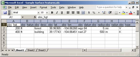
The TAP Surface Feature import assumes the data will be in “Sheet1:”
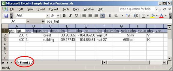
If the Excel sheet has a different name, you can right-click on the tab to rename it to Sheet1.
If you are using an Excel file with different header names (or no header names) you can save the file in Excel to a different name (using the Edit-SaveAs menu), then use the copy to change the headings to match the TAP import requirements.
Be sure the coordinates are in decimal degrees. If the coordinates are in a different format (such as degrees, minutes and seconds) you must convert to decimal degrees. You may be able to do this with an Excel macro or other function.
|
|
Copyright 2007 by SoftWright LLC