Q: What is the difference between the Coverage Area "Distance between points" and the Topographic Data "Increment" on the Area Coverage form?
A: These two fields allow you to specify independent values for the topographic elevation data resolution, and the resolution for computing the field or shadow values.
In TAP6 (HDCoverage) the Topo Data Step value is shown in the Topo Data section, and the Coverage Step value is shown in the Coverage Area Section:

Note in TAP5 and earlier, the values are shown on the TAP Area Coverage Setup form:
The Topographic Data Increment value specifies where the distance between the radial elevation data values along the radial.
The Coverage Area Distance Between Points value indicates the distance between the field calculations, effectively determining how much detail will be generated.
Now (in this example), we have an elevation data out to 50 miles in 0.1 mile steps. Suppose we need just a quick, preliminary study of the field values, so in the interest of speeding up the study, we set the field strength start, stop and step values as 1.0 to 50.0 in 1.0 mile steps. This would mean the computed field values would be a mile apart, which does not provide a lot of detail, but might be sufficient for a general look to compare five or six sites. Once the number of sites is narrowed down, a more detailed study (say, 0.25 mile steps) could be done using the same elevation data step.
In both cases (1.0 and 0.25 coverage steps) each field strength calculation along the radial will be a separate path study, using all of the elevation data points from the site to the point under study, at 0.1 mile increments (the step of the elevation data).
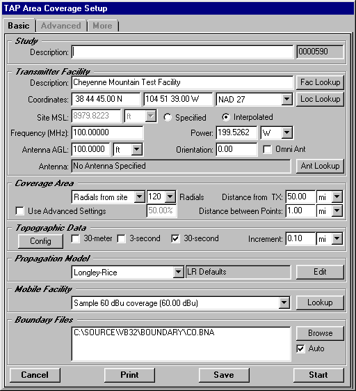
In the following sketch, the solid dots represent the topography (in 0.1 mile increments), and the hollow dots represent two of the receive locations in the first "preliminary" study, in 1.0 mile increments.
The dotted lines represent the line-of-sight for each of the studies. In both cases, the receiver antenna height above ground (AGL) is added to the topography elevation value at the receiver location, and all of the path elevation data from the transmitter site to the receiver location is considered in computing obstruction losses, path roughness, and other topography-dependent parameters (depending on the propagation model being used).
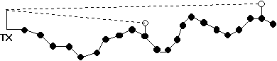
The second case (with field calculations at 0.25-50.0, .025 step) is illustrated below:
In this case, some of the receive locations (i.e., at 0.25, 0.75, etc.) are actually located between the elevation data points, so the ground elevation at these sites is interpolated from the radial data.
You can see from these two examples that the step distances for radial elevation data and field strength calculations can be adjusted independently to best suit your particular situation.