Q: How can I plot a map drawn in SURFER to a particular scale, such as 1:250,000?
A: If topographic data to be used with SURFER (or other mapping software) uses latitude and longitude as the units of horizontal measurement, it is usually important to correct for the differences in miles per degree longitude versus miles per degree latitude using the SCALE dialog box in the SURFER Map menu.
Map Aspect Ratios
Since lines of longitude converge at the poles, the distance represented by one degree of longitude varies with latitude, and the miles-per-degree (MPD) value for longitude (east-west measurements) is the same as the MPD for latitude (north-south measurements) only at the equator. For example, look at the lines of latitude and longitude on a globe. They form approximate squares at the equator, and progressively narrower rectangles as you go north or south toward either pole.
As a result, maps with height and width equal in latitude and longitude values are not normally square. For example, a typical USGS 7-1/2 minute topographic map is 7-1/2 minutes on a side both vertically and horizontally, but the map is not square. It is a rectangle higher than it is wide, and the aspect ratio between height and width varies depending on what area is being mapped. In central Colorado a sample 7-1/2' map represents approximately 8.62 miles on the north-south axis and approximately 6.75 miles on the east-west axis. If the map was drawn as a square (7-1/2' on a side) it would have to be distorted, with distances in the north-south direction shortened.
When topographic data is plotted with SURFER and the horizontal measurements (for locating the elevation points) are in latitude and longitude, a 7-1/2' square area would plot as a square, distorting the aspect ratio of the area. This is because SURFER is a general 2- and 3-D plotting program (rather than a mapping program that adjusts for differences in MPD for latitude and longitude). When SURFER is given data values that show 7-1/2' in the X (east-west) direction and 7-1/2' in the Y (north-south) direction, it will plot those values as a square (7-1/2' x 7-1/2') area. (If the file to be plotted with SURFER is created by the TAP program (Area Data or Field Strength) that saves the horizontal values as distances, the difference in MPD is corrected automatically when the distance values are computed.)
The SCALE option in the MAP menu allows you to adjust the aspect ratio to compensate for the MPD differences using the "1.0 inch = ___ map units" for the x and y scales.
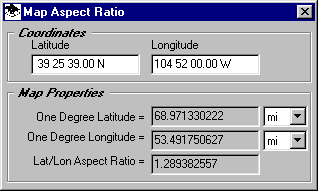
Determining Aspect Ratio
You can determine an approximate aspect ratio by simply measuring a topographic map from the general area of interest as as described above. A more precise method (and necessary for setting exact scales with SURFER as described below) is to use the TAP Utilities menu and select "Map Aspect Ratio".
Enter coordinates in the area of interest (such as a transmitter site) to get the aspect ratio, and the number of miles per degree for both latitude and longitude.
Setting SURFER Scale Values
If you are not concerned about the exact scale of your SURFER plot (you just want to see the area on the page) you can use the aspect ratio to adjust only one of the "map unit" values in the SCALE option in the MAP menu. For example, if the default value for the x-axis is shown as
you can set the y-axis value as the aspect ratio times the x-axis value, such as
For example, if you have computed that the values are 86.63 km/deglon and 111.03 km/deglat (Denver area), the y-axis value would be computed as:
and enter the value of
(Note that you must remove the "Proportional X-Y Scaling" option on the SCALE dialog box in order to apply independent scale factors to the axes.)
Setting a Specific Scale
If you want to print the SURFER output at a specific scale (such as 1:250,000 to match a pre-printed USGS map, etc.), the exact values for kilometers per degree longitude and kilometers per degree latitude must be used to compute the scale per map units.
First, the scale value must be determined. A scale of 1:250,000 really means that one inch on the map represents 250,000 inches in the real world (hence the ratio of 1:250,000). The value of 250,000 inches can be converted to a more convenient unit, such as kilometers:
The map ratio is then 1 inch = 6.35kilometers. (An approximation of this value is sometimes printed on the map itself.)
Next, consider the equation presented on the SURFER dialog box:
Since the "map units" we are considering are degrees, the prompts are really asking for:
Substituting the appropriate units for the example Denver area location:
For the X-Axis:
or:
For the Y-Axis:
or:
Using these values will give you a map with the correct aspect ratio for the sample in the Denver area, and at the desired scale on the printed output. (Be sure to compute and use your own values of kilometers (or miles) per degree latitude and longitude for the area you are working in.) When you plot the map, also be sure to select the "Truncate" option or the "Tile" option in the SURFER Print dialog box, and not the "Fit to Page" option which will automatically adjust the scale to fit on the page and ignore your carefully computed scale factors!
Copyright 2000 by SoftWright LLC