Q: How do I mark coordinates on a map from the Fixed Facility Data Base?
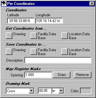
A: The "Pin" function allows you to mark coordinates on a map, as well as transfer coordinates between the map, the Fixed Facility Data Base, and the Location Data Base. Click the Pin button:

If you want to mark a particular site on the map, you can enter the coordinates manually, then use the "Save Coordinates to ..." section and click the "Drawing" button. Note that the site is marked with the symbol you set in the "Drawing Mark" section.

If you want to mark a site from the Fixed Facility or Location Data Base, use the "Get Coordinates from ..." section and click the appropriate button. Then you can add the site to the map using the "Save Coordinates to ..." section and the "Drawing" button.
If you want to save a site from the drawing to either the Fixed Facility or Location Data Base use the "Get Coordinates from ..." section and click the "Drawing" button to get the coordinates, then in the "Save Coordinates to ..." section and the appropriate button. A record will be created in the corresponding data base with the specified coordinates and description.
The "Map Register Marks" section allows you to mark a number of locations on the map at the interval (in degrees) that you specify. This feature is typically used to add marks at an interval (1 degree, .5 degree, etc.) that corresponds to printed register marks on a paper map. The marks facilitate aligning a TAP coverage study plotted on a transparency on a paper map. The register marks are drawn at the specified interval in the area currently shown in the Map Window. If you want to draw the marks only on a part of the map, zoom into that area before using the function.
Copyright 1999 by SoftWright LLC