USGS SRTM “FINISHED” Data
Q: What is “finished” topographic data?
A: The original SRTM (Shuttle Radar Topography Mission) topographic data (in the .HGT format) contained anomalies, such as spikes or missing elevations. The “finished” grade data has most of these anomalies removed by the USGS.
Note that all values in this example are for demonstration purposes only. You should determine appropriate settings for your application.
SoftWright has updated our 3-second SRTM data files with the Finished SRTM data. This article discusses:
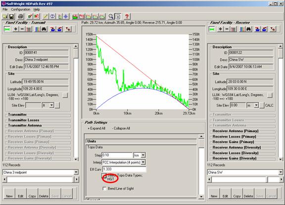
For example, consider a path as shown below, plotted with the original SRTM data in the .HGT format:
Notice especially the sea-level portion of the path (0 MSL), from about 10km to the end. This clearly illustrates the “unfinished” SRTM data, particularly problematic over areas of water.
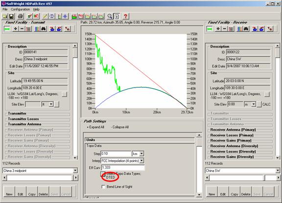
The same path drawn using the Finished SRTM data (in the DTED format) removes most of the anomalies:
For information about obtaining replacement files for SRTM data purchased from SoftWright, please contact SoftWright Sales.
The process of replacing the older .HGT format files consists of three steps:
Since the unfinished (.HGT) and finished (.DT1) files are both 3-second resolution for most of the world, it is recommended that you remove the replaced .HGT files from your TAP system to avoid the possibility of using the older data. You can delete the .HGT files or move them to a different folder that will not be indexed. Then after you copy the new files you can use the ReIndex function in TAP to create a new index file without including the folder where the .HGT files are located. (While the finished files should cover the same area as the replaced unfinished files, you should keep a copy of the old files in case a missing area is discovered. You will then have the older data available until the finished files are available from the USGS. In this event, you should contact SoftWright support.
When you receive new finished files, they will be in the DTED format (.DT1 files). This format requires a very specific file naming and folder naming structure. It is imperative that you maintain the folder and file naming structure of the files in order for the elevation data values to be usable by TAP or any other DTED-compatible software.
If you receive the new files on a CD or external hard disk, and they are not in a zipped file, you can copy the entire disk, including all the folders, to your desired location, such as the DATA folder where TAP is installed. DO NOT copy individual files, since the file contents are defined by both the file names and the folder names containing the files, as described below.
If you receive a zipped file containing Finished SRTM data in the DTED format, unzip the file into the folder where you want to use the data, and be sure that the sub-folders are created during the unzip process. If you have any questions or need help, please contact SoftWright support:
TAP uses a topographic data file index to find and read the appropriate files when you draw a path profile, run a coverage study, or other functions in TAP that use the elevation data. The index includes information about the resolution of the files (such as 1-second data, 3-second data, etc.) and TAP always uses the highest resolution data available for a particular area, even mixing resolutions if parts of the area needed are available in different resolution values.
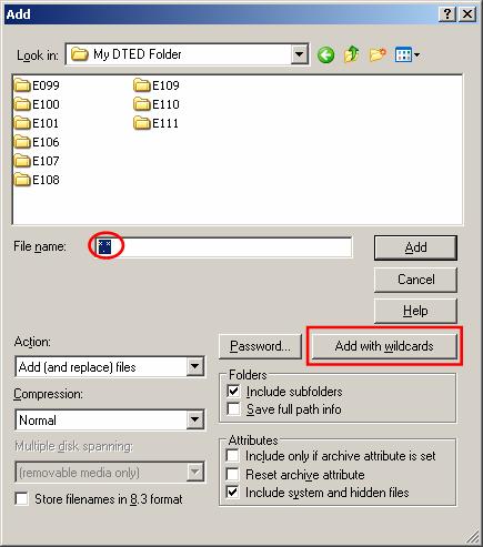
If you need to move finished SRTM files in the DTED format from one machine to another and you need to compress the files with a “zip” utility, you must include the path information in the zipped file.
Suppose you have DTED data in a folder named “My DTED Folder” and you want to move the data by compressing it to a ZIP file using the WinZip™ software. Open the folder containing the DTED folders and use the “Add with wildcards” button:
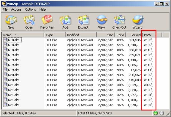
When the process is completed you will see the path information included in the zipped file.
When you unzip the file to the target location, check to be sure that the DTED folders have been created.
If the software you are using does not have an option to include the path information, you should carefully copy each folder of files into a folder with exactly the same name on the target machine. Without the folder and file names correctly assigned, the contents of the elevation files will be useless. (Or worse, incorrectly naming or copying folder or file names will result in erroneous results as the elevation values in one file are mistakenly read for a different location.)
If you need more information, the format is well documented:
http://www.fas.org/irp/program/core/dted.htm
http://www.vterrain.org/Elevation/dted.html
http://earth-info.nga.mil/publications/specs/printed/89020B/89020B.pdf
The southwest corner of each file is defined by the filename, for example, N13, for latitude 13N, and the folder containing the file, such as W088 for longitude 88W. The file extent (.dt1) defines the "level" or resolution of the DTED data.
|
|
Copyright 2007 by SoftWright LLC