
Q: How do I use the Land Use data in TAP?
A: The TAP Land Use Module is based on the USGS Land Use and Land Cover (LULC) data from 1:250,000 scale maps.
The Land Use data can be used with TAP Area Coverage studies, as well as Path Profiles, Single-Point Field calculations, the Field Preview function and other TAP functions. The Land Use module enables you to find the land classification and apply it to many parts of TAP.
General Concepts
The USGS LULC files categorize land use in 200 square meter cells, with each cell assigned an attribute, such as Urban, Agricultural, Forest, etc. (For a complete listing of the categories and subcategories, see National Mapping Program Data Users Guide 4, Land Use and Land cover Digital Data from 1:150,000- and 1:100,000-scale Maps.) When the files are imported into the TAP format, TAP can determine the classification at a given set of coordinates.
In addition, TAP includes a Land Use Loss Database that correlates the land classification with a loss value as a function of frequency. When TAP is used for an area coverage study or single-point field calculation, the environment of the receiver location can be determined from the Land Use data, and a user-specified loss value can be applied. For example, if you want to include an additional loss of 3dB in your frequency band whenever a receiver location is in a forest area, and 6db when in an urban area, the Land Use Loss Database enables you to specify that condition. At the same time, you can specify a loss of 7dB for forest and 12dB for urban in a different frequency band. This approach gives you great flexibility in applying the effects of the land use information to your coverage studies.
The Land Use Loss Database also includes an option to specify an Area Type for the Okumura propagation model for each land use classification and frequency range. This enables the Okumura model to be much more adapted to the actual environment for a study in a given area.
The TAP Land Use files are one-degree square areas, and follow a naming convention similar to the SoftWright topographic elevation data files.
For the Land Use files, the convention is
LwwwnnNW.LUC
Where
To specify in TAP where the files are located, use the Land Use selection in the Configuration menu:
The Land Use Data File Path(s) form will be displayed:

Use the Add and Remove buttons to specify any path(s) where you install the Land Use files. The Diagnostics section reports several potential problems, such as a directory that does not contain any Land Use files, duplicate land use files in multiple directories, etc.
As with the TAP Topographic Data configuration, once this configuration has been specified, you will not need to open this form unless you need to make a change in where you want TAP to look for the files.
In order to associate loss values with the various combinations of frequency and land use categories, the Land Use Loss Database can contain numerous configurations, or "templates". Each template contains a set of loss values as a function of frequency and land use, and you can select which template to use for a particular coverage study.
The default templates supplied with the TAP Land Use Module are:
Note that these are representative samples only. You must verify the applicability of the Land Use Loss values based on frequency and land classifications that are most appropriate to your application.
The Loss Database Editor enables you to modify these templates, or to add your own. The editor is accessible from the Editors menu under Land Use data:

The Loss DB Editor form is displayed:

You can select the Template, and the Frequency Range in the pulldown lists near the top of the form, or create a new Template or Frequency Range with the New buttons.
In this example, note that some of the categories (51-54) have not been specified. In such cases, those land use classifications will be ignored in a coverage study.
You can also use the Loss Database Editor to specify the Okumura categories to associate with each land use category for each frequency range. The options are available in a pulldown list for the Area Type and Street Orientation columns:

The "Default for Study" option forces the program to use whatever default is set when the Okumura study is set up, ignoring the land use association.
Note that these are representative samples only. You must verify the applicability of the Okumura values based on frequency and land classifications that are most appropriate to your application.
As mentioned above, the Loss Database permits you to set up multiple templates for different conditions. For example, selecting another of the sample templates and finding a similar frequency range shows different loss values will be applied using that template:

Area Coverage Studies
To include Land Use data in an Area Coverage study, you must select the Advanced parameters by checking the "Use Land Use Data" checkbox on the HDCoverage form:

Mark the "Include Land Use Data" checkbox, and select the template to use.
When the area coverage study is executed, the land use values will be included in the calculation of the field strength at each receiver location if the needed .LUC file for that area is found.
Path Profiles
To use the Land Use data with a path profile, click the Include Land Use Data checkbox:
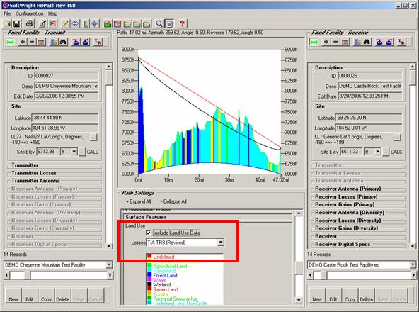
The Land Use legend will be displayed showing the colors used for each land use category. The land use values will be displayed on the profile below the terrain.
The land use category and associated loss value will be displayed in the Mouse Location window as you move the mouse on the profile graphic.

This can be useful in getting a better idea of what the conditions are along the path, such as vegetation and man-made obstructions.
You can also use the USGS Land Use data as a guideline for creating TAP Surface Feature files. The Land use data on the profile can give you an idea of the surface obstacles (vegetation, buildings, etc.) and you can create Surface Feature files to represent those obstructions.
|
|
Copyright 2000 by SoftWright LLC