
Summary
The SoftWright Rounded Obstacle (SWRO) model is based on Section 7 ("Diffraction Over a Single Isolated Obstacle") of Tech Note 101 (Transmission Loss Predictions for Tropospheric Communication Circuits, 1967, NTIS), treating path obstructions as rounded obstacles as described in Section 7.2. In addition, methods from Section 9 ("Forward Scatter") are used to compute tropospheric scatter losses. The two loss components may be combined in any of several user-selected methods. Some of the source code for the model was adapted from the program QZGBT used for protecting the rf noise floor at the National Radio Astronomy Observatory (Green Bank WV) radio astronomy site.
Selection of Path Obstacles
In any program that attempts to automate the calculation of path loss (in contrast to step by step user-intervention in the process) a critical step is the selection of path obstacles to consider. Since the topographic data for a path is most likely available in the form of an array of individual elevation values and a corresponding array of distance values, the program must process the arrays and determine which values represent peak obstructions, a task that the human engineer does more or less intuitively by looking at a profile plot of the path.
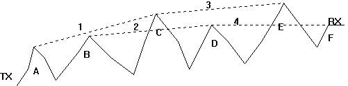
The SWRO model first determines the vertical range of elevations along the path. Then, beginning with the highest elevation on the path, the program creates hypothetical "contours" in five-foot increments for the entire length of the path. (The default value of five feet can be adjusted using the "Peak Resolution" value in the program.) That is, the first contour represents a band along the path between the maximum elevation and five feet lower, the next contour is from five feet down to ten feet, etc.
The program analyzes every point on the path to determine if it is within one of these bands. A "peak" is defined whenever a series of consecutive points along the path enter the bottom of a particular band and leave through the bottom of that band without penetrating the top of the band. In the simplified illustration below, the dashed lines represent the hypothetical contour bands for the profile. In each case, the "peak" is represented at the center of the range of the penetration of the contour band. An average radius of the peak is computed using the width and height in order to apply the Tech Note 101 equations for a rounded obstacle.
After the peaks along the path are determined, further analysis on the path elevation peak values is performed to determine the horizon peaks along the path. Starting with the transmitter site (elevation plus antenna height above ground) all of the peaks are evaluated to determine which one represents the highest elevation angle, i.e., the horizon from that starting point. Then the starting point is moved to that peak, and the remainder of the path is examined to find the horizon from that point, and so on until all of the path horizons (for one or more segments of the path) have been determined.
Finally, using the horizon information for each segment, any intermediate peaks (i.e., between each starting point and the corresponding horizon) are examined to determine the difference in distance between the direct path (R) and the indirect path(R1 + R2).
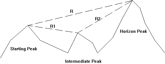
If the indirect path length exceeds the direct path length by .088 wavelength or more, the intermediate point is considered to not affect the study and is discarded.
The remaining peaks are then treated as multiple path segments:
|
Path |
Starting Point |
|
Ending Point |
|
|
|
|
|
|
|
|
|
|
|
|
|
|
|
|
|
|
|
|
The diffraction loss for each segment is computed based on Tech Note 101, Section 7, "Diffraction Over a Single Isolated Obstacle" (and information in Annex III.2). The Scatter loss is computed based on Tech Note 101, Section 9, "Forward Scatter" (and information in Annex III.5).
Calculation of Obstacle Radius
The program will compute the obstacle radius for use in the equations of Tech Note 101 based on the difference in height (dH) and distance (dD) between the peak and the adjacent points on the path. The radius is computed based on the function 1/Sin2a, where a is the computed angle determined by dH and dD. The computed radius is limited to a maximum value of 5000 feet (based on the QZGBT program).
Selection of Scatter and Diffraction Loss
The program will compute both Scatter loss and the total diffraction loss for all obstacles on a path. The following options are available for combining the losses.
DIFFRACTION Always use Diffraction loss and ignore the computed tropospheric scatter loss.
SCATTER Always use Scatter loss and ignore computed obstacle diffraction loss.
MINIMUM LOSS Always use the lower loss value. This will result in a "worst case" (highest field strength) for interfering studies. For example, this is the mode that should be used for interference studies for protected facilities, such as the Green Banks site.
MAXIMUM LOSS Always use the higher loss value. This will result in a "worst case" (lowest field strength) for service studies.
FIGURE 9.9 Combine the scatter and diffraction loss values as described in Section 9.5 of Tech Note 101, using Figure 9.9. This method assigns a cumulative loss value based on the difference between the computed scatter and diffraction loss values. This is the recommended option for most applications.
Rounded Obstacle Template
Like other propagation models in the TAP software, the SoftWright implementation of the Rounded Obstacle model uses templates for setting the variable parameters in the model. Multiple user-specified templates can be created to provide uniformity of the selection of parameters for different studies.
The Rounded Obstacle model template allows the selection of the following parameters:
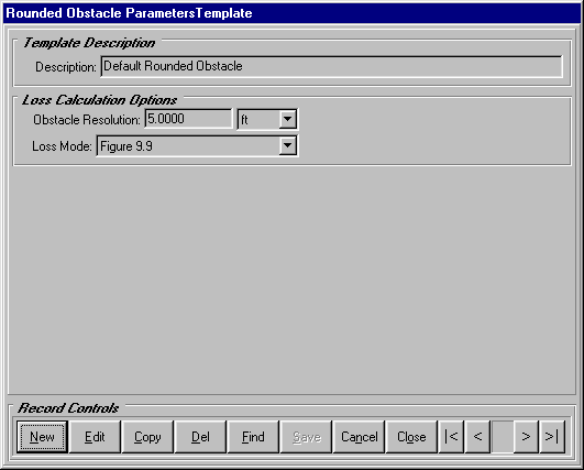
Description The description is used to organize different templates and retrieve them for use in studies later.
Obstacle Resolution This value is used in the Peak Selection process described above.
Loss Mode This is the attenuation mode for selecting Scatter or Diffraction losses as described above.
|
|
I'm interested! Please click here to jump to an online form which helps us better understand your needs. Then we will be able to respond to your request with information that is most useful to you. |
|
|
Copyright 2001 by SoftWright LLC, Aurora, Colorado USA